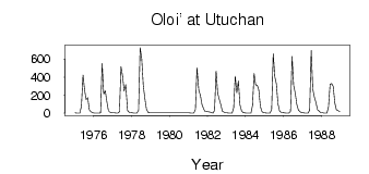
Oloi' at Utuchan
Anadyr Kolyma
| PointID: | 5904 |
Code: | 1371 |
Latitude (decimal degrees): | 65.67 |
Longitude (decimal degrees): | 162.43 |
Drainage Area (km2): | 15700.00 |
Source: | SHI |
Hydrological Zone: | Anadyr Kolyma |
Name: | Oloi' at Utuchan |
Field Definitions
Site Time Series Plot:

Site Data File:
(Units: m3/s)
| ID | Year | Jan | Feb | Mar | Apr | May | Jun | Jul | Aug | Sep | Oct | Nov | Dec |
|---|
| 5904 | 1975 | 3.01 | 1.42 | 0.61 | 0.58 | 82.00 | 424.00 | 256.00 | 153.00 | 173.00 | 38.20 | 15.20 | 5.65 |
| 5904 | 1976 | 1.75 | 1.02 | 0.81 | 0.89 | 4.83 | 551.00 | 212.00 | 248.00 | 128.00 | 28.70 | 8.60 | 5.96 |
| 5904 | 1977 | 4.23 | 2.75 | 1.27 | 0.36 | 17.00 | 517.00 | 414.00 | 245.00 | 317.00 | 31.20 | 9.49 | 5.98 |
| 5904 | 1978 | 4.19 | 2.42 | 2.20 | 1.75 | 32.60 | 727.00 | 608.00 | 309.00 | 163.00 | 47.30 | 11.20 | 5.23 |
| 5904 | 1981 | 3.56 | 2.23 | 1.66 | 1.46 | 41.30 | 503.00 | 254.00 | 197.00 | 97.10 | 49.90 | 17.70 | 17.90 |
| 5904 | 1982 | 16.00 | 14.20 | 7.49 | 1.42 | 31.40 | 467.00 | 222.00 | 154.00 | 95.10 | 20.80 | 13.60 | 5.44 |
| 5904 | 1983 | 3.37 | 2.29 | 1.59 | 1.16 | 59.00 | 411.00 | 226.00 | 358.00 | 93.50 | 27.40 | 8.45 | 4.52 |
| 5904 | 1984 | 2.39 | 1.26 | 1.04 | 0.92 | 87.30 | 442.00 | 315.00 | 311.00 | 255.00 | 72.80 | 18.50 | 5.16 |
| 5904 | 1985 | 3.11 | 2.45 | 1.50 | 1.02 | 44.90 | 663.00 | 407.00 | 327.00 | 105.00 | 26.80 | 8.39 | 7.23 |
| 5904 | 1986 | 3.91 | 1.85 | 1.16 | 1.23 | 20.90 | 629.00 | 305.00 | 224.00 | 96.40 | 34.80 | 14.90 | 6.80 |
| 5904 | 1987 | 3.29 | 1.36 | 0.76 | 0.78 | 34.00 | 697.00 | 269.00 | 177.00 | 119.00 | 40.20 | 23.30 | 7.56 |
| 5904 | 1988 | 6.15 | 2.22 | 1.10 | 1.06 | 69.60 | 319.00 | 329.00 | 296.00 | 115.00 | 37.70 | 26.00 | 14.60 |
 Return to R-Arctic Net Home Page


 Return to R-Arctic Net Home Page