Omolon at Omolon
Anadyr Kolyma
| PointID: | 5903 |
Code: | 1368 |
Latitude (decimal degrees): | 63.32 |
Longitude (decimal degrees): | 158.43 |
Drainage Area (km2): | 3710.00 |
Source: | SHI |
Hydrological Zone: | Anadyr Kolyma |
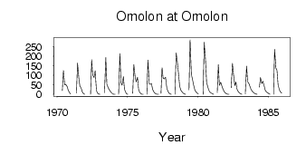
Name: | Omolon at Omolon |
Field Definitions
Site Time Series Plot:
Site Data File:
(Units: m3/s)
| ID | Year | Jan | Feb | Mar | Apr | May | Jun | Jul | Aug | Sep | Oct | Nov | Dec |
|---|
| 5903 | 1970 | | | | | 19.40 | 125.00 | 49.60 | 52.10 | 41.50 | 22.20 | 11.10 | 1.84 |
| 5903 | 1971 | | | | | 5.62 | 164.00 | 85.80 | 42.00 | 34.90 | 12.90 | 3.65 | 0.20 |
| 5903 | 1972 | | | | | 0.79 | 182.00 | 99.00 | 88.20 | 124.00 | 20.00 | 6.44 | 1.66 |
| 5903 | 1973 | 0.18 | | | | 8.25 | 193.00 | 53.30 | 34.20 | 24.30 | 15.50 | 6.80 | 1.95 |
| 5903 | 1974 | 0.45 | 9.0e-03 | | | 0.61 | 214.00 | 60.00 | 48.70 | 92.40 | 26.80 | 9.72 | 1.97 |
| 5903 | 1975 | 0.06 | | | | 4.55 | 156.00 | 92.70 | 63.70 | 89.40 | 25.90 | 10.70 | 2.44 |
| 5903 | 1976 | 0.74 | 0.16 | | | 0.23 | 180.00 | 56.40 | 51.30 | 57.40 | 24.90 | 12.50 | 4.82 |
| 5903 | 1977 | 1.97 | 0.49 | 8.0e-03 | | 4.66 | 140.00 | 83.20 | 81.30 | 89.70 | 32.10 | 15.90 | 5.90 |
| 5903 | 1978 | 1.79 | 0.04 | | | 0.49 | 217.00 | 174.00 | 105.00 | 43.20 | 22.30 | 13.20 | 5.87 |
| 5903 | 1979 | 1.75 | 0.27 | | | 23.60 | 286.00 | 105.00 | 77.60 | 44.40 | 22.60 | 13.00 | 6.42 |
| 5903 | 1980 | 1.45 | | | | 0.74 | 273.00 | 181.00 | 64.80 | 40.20 | 19.50 | 10.20 | 6.38 |
| 5903 | 1981 | 3.03 | 0.40 | | | 7.82 | 156.00 | 46.90 | 63.30 | 45.10 | 25.10 | 14.00 | 6.65 |
| 5903 | 1982 | 2.51 | 0.86 | 0.22 | | 34.90 | 162.00 | 103.00 | 45.60 | 63.90 | 26.20 | 14.50 | 6.69 |
| 5903 | 1983 | 2.82 | 0.65 | | | 1.10 | 147.00 | 65.10 | 58.40 | 39.90 | 24.30 | 15.50 | 9.50 |
| 5903 | 1984 | 4.96 | 2.04 | 0.25 | | 37.20 | 88.40 | 56.10 | 68.40 | 43.40 | 20.90 | 13.40 | 7.91 |
| 5903 | 1985 | 3.46 | 0.92 | | | 0.26 | 235.00 | 139.00 | 126.00 | 50.70 | 22.90 | 13.40 | 6.56 |
 Return to R-Arctic Net Home Page