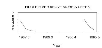
| PointID: | 589 | Code: | 07AA010 | Latitude (decimal degrees): | 53.17 | Longitude (decimal degrees): | -117.83 | Drainage Area (km2): | 203.00 | Source: | Hydat | Hydrological Zone: | Mackenzie | Name: | FIDDLE RIVER ABOVE MORRIS CREEK |
|---|
| Download | |
|---|---|
| Site Descriptor Information | Site Time Series Data |
| Link to all available data | |
| ID | Year | Jan | Feb | Mar | Apr | May | Jun | Jul | Aug | Sep | Oct | Nov | Dec |
|---|---|---|---|---|---|---|---|---|---|---|---|---|---|
| 589 | 1967 | 4.36 | 2.11 | 1.48 | 1.30 | ||||||||
| 589 | 1968 | 6.92 | 4.98 | 2.82 | 1.76 |
 Return to R-Arctic Net Home Page