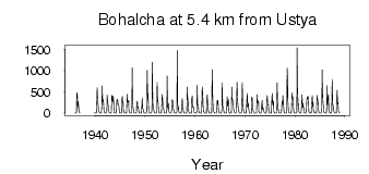
| PointID: | 5878 | Code: | 1176 | Latitude (decimal degrees): | 62.10 | Longitude (decimal degrees): | 150.67 | Drainage Area (km2): | 13600.00 | Source: | SHI | Hydrological Zone: | Anadyr Kolyma | Name: | Bohalcha at 5.4 km from Ustya |
|---|
| Download | |
|---|---|
| Site Descriptor Information | Site Time Series Data |
| Link to all available data | |
| ID | Year | Jan | Feb | Mar | Apr | May | Jun | Jul | Aug | Sep | Oct | Nov | Dec |
|---|---|---|---|---|---|---|---|---|---|---|---|---|---|
| 5878 | 1936 | 6.62 | 3.11 | 2.53 | 2.12 | 483.00 | 459.00 | 138.00 | 276.00 | 200.00 | 57.50 | 21.60 | 8.38 |
| 5878 | 1939 | 0.19 | 17.60 | 8.66 | |||||||||
| 5878 | 1940 | 3.57 | 2.15 | 2.42 | 2.83 | 325.00 | 605.00 | 304.00 | 261.00 | 106.00 | 28.00 | 14.60 | 7.81 |
| 5878 | 1941 | 3.34 | 1.47 | 0.98 | 1.02 | 202.00 | 639.00 | 273.00 | 324.00 | 260.00 | 60.00 | 22.50 | 9.70 |
| 5878 | 1942 | 3.36 | 1.66 | 0.95 | 0.54 | 71.80 | 424.00 | 286.00 | 183.00 | 118.00 | 30.20 | 14.00 | 8.74 |
| 5878 | 1943 | 6.74 | 4.72 | 3.77 | 3.83 | 418.00 | 407.00 | 272.00 | 277.00 | 396.00 | 80.10 | 13.40 | 8.16 |
| 5878 | 1944 | 3.29 | 1.16 | 0.59 | 0.91 | 315.00 | 301.00 | 326.00 | 204.00 | 202.00 | 154.00 | 22.20 | 9.86 |
| 5878 | 1945 | 2.60 | 0.66 | 0.44 | 0.95 | 290.00 | 393.00 | 249.00 | 275.00 | 86.80 | 24.30 | 15.80 | 8.63 |
| 5878 | 1946 | 3.71 | 1.37 | 0.84 | 1.15 | 183.00 | 442.00 | 263.00 | 264.00 | 300.00 | 78.10 | 11.30 | 5.40 |
| 5878 | 1947 | 2.09 | 0.95 | 0.76 | 1.57 | 9.24 | 1070.00 | 337.00 | 125.00 | 76.90 | 27.00 | 8.46 | 3.69 |
| 5878 | 1948 | 1.81 | 0.61 | 0.34 | 1.52 | 215.00 | 287.00 | 124.00 | 150.00 | 109.00 | 28.00 | 6.04 | 2.82 |
| 5878 | 1949 | 1.26 | 0.40 | 0.23 | 0.27 | 91.40 | 358.00 | 104.00 | 102.00 | 63.70 | 19.60 | 6.10 | 1.89 |
| 5878 | 1950 | 0.98 | 0.77 | 0.61 | 0.49 | 24.80 | 1010.00 | 320.00 | 466.00 | 172.00 | 28.10 | 11.40 | 5.92 |
| 5878 | 1951 | 2.57 | 1.27 | 0.80 | 0.42 | 75.90 | 1200.00 | 370.00 | 166.00 | 105.00 | 53.30 | 16.20 | 6.65 |
| 5878 | 1952 | 3.01 | 1.05 | 0.35 | 0.47 | 48.00 | 720.00 | 260.00 | 301.00 | 114.00 | 38.20 | 11.00 | 3.19 |
| 5878 | 1953 | 1.66 | 1.09 | 0.57 | 0.53 | 265.00 | 442.00 | 321.00 | 132.00 | 106.00 | 42.00 | 14.00 | 5.41 |
| 5878 | 1954 | 1.71 | 0.91 | 0.47 | 1.77 | 76.00 | 875.00 | 167.00 | 119.00 | 229.00 | 46.60 | 13.10 | 4.36 |
| 5878 | 1955 | 1.71 | 0.65 | 0.37 | 0.18 | 169.00 | 313.00 | 302.00 | 184.00 | 109.00 | 35.90 | 10.70 | 6.33 |
| 5878 | 1956 | 4.70 | 3.42 | 2.69 | 2.72 | 34.10 | 1480.00 | 242.00 | 86.70 | 157.00 | 35.10 | 12.10 | 6.23 |
| 5878 | 1957 | 2.40 | 0.62 | 0.27 | 0.28 | 151.00 | 348.00 | 164.00 | 116.00 | 51.20 | 28.70 | 11.10 | 4.09 |
| 5878 | 1958 | 1.64 | 1.00 | 0.47 | 0.26 | 45.40 | 614.00 | 386.00 | 287.00 | 104.00 | 27.20 | 9.48 | 2.59 |
| 5878 | 1959 | 1.33 | 0.87 | 0.29 | 0.14 | 346.00 | 400.00 | 143.00 | 151.00 | 140.00 | 33.20 | 12.20 | 3.48 |
| 5878 | 1960 | 1.12 | 0.61 | 0.48 | 0.47 | 45.50 | 655.00 | 234.00 | 180.00 | 119.00 | 26.30 | 10.10 | 6.55 |
| 5878 | 1961 | 3.16 | 1.25 | 0.62 | 1.53 | 90.60 | 625.00 | 471.00 | 180.00 | 136.00 | 33.30 | 11.20 | 4.20 |
| 5878 | 1962 | 1.73 | 0.32 | 0.16 | 0.28 | 237.00 | 429.00 | 233.00 | 145.00 | 57.50 | 22.50 | 11.30 | 3.85 |
| 5878 | 1963 | 2.18 | 1.97 | 1.11 | 0.64 | 18.00 | 1020.00 | 392.00 | 199.00 | 80.10 | 32.70 | 11.80 | 5.62 |
| 5878 | 1964 | 1.92 | 0.30 | 0.12 | 0.11 | 122.00 | 297.00 | 217.00 | 306.00 | 78.80 | 24.30 | 6.14 | 4.19 |
| 5878 | 1965 | 1.70 | 0.77 | 0.32 | 0.37 | 93.80 | 717.00 | 162.00 | 162.00 | 99.20 | 24.30 | 9.93 | 2.94 |
| 5878 | 1966 | 0.49 | 0.36 | 0.22 | 0.15 | 156.00 | 389.00 | 156.00 | 244.00 | 327.00 | 26.30 | 14.40 | 7.06 |
| 5878 | 1967 | 2.60 | 1.25 | 0.61 | 0.34 | 616.00 | 314.00 | 321.00 | 235.00 | 137.00 | 47.80 | 20.40 | 7.28 |
| 5878 | 1968 | 0.53 | 0.34 | 0.30 | 0.62 | 522.00 | 729.00 | 285.00 | 148.00 | 93.90 | 43.20 | 6.48 | 0.87 |
| 5878 | 1969 | 0.17 | 0.10 | 0.04 | 0.02 | 79.50 | 722.00 | 380.00 | 154.00 | 81.00 | 24.20 | 11.50 | 4.46 |
| 5878 | 1970 | 1.78 | 0.67 | 0.40 | 0.48 | 280.00 | 470.00 | 144.00 | 163.00 | 242.00 | 68.40 | 12.80 | 4.60 |
| 5878 | 1971 | 1.14 | 0.50 | 0.25 | 0.22 | 383.00 | 344.00 | 192.00 | 94.60 | 50.70 | 20.80 | 7.45 | 1.83 |
| 5878 | 1972 | 0.50 | 0.17 | 0.08 | 1.41 | 172.00 | 441.00 | 238.00 | 292.00 | 255.00 | 36.20 | 13.40 | 5.32 |
| 5878 | 1973 | 1.74 | 0.74 | 0.53 | 0.30 | 200.00 | 306.00 | 88.40 | 114.00 | 121.00 | 57.50 | 13.40 | 7.33 |
| 5878 | 1974 | 4.80 | 1.73 | 0.62 | 0.76 | 289.00 | 418.00 | 224.00 | 189.00 | 198.00 | 54.50 | 11.80 | 4.26 |
| 5878 | 1975 | 1.14 | 0.40 | 0.30 | 0.28 | 251.00 | 462.00 | 195.00 | 254.00 | 287.00 | 45.80 | 11.10 | 5.79 |
| 5878 | 1976 | 1.92 | 0.49 | 0.15 | 0.12 | 127.00 | 714.00 | 168.00 | 91.30 | 84.00 | 19.90 | 7.74 | 3.99 |
| 5878 | 1977 | 0.91 | 0.26 | 0.12 | 0.16 | 209.00 | 282.00 | 219.00 | 416.00 | 201.00 | 56.60 | 13.40 | 5.60 |
| 5878 | 1978 | 1.90 | 0.88 | 0.31 | 0.34 | 84.00 | 1070.00 | 816.00 | 293.00 | 75.60 | 22.40 | 10.80 | 4.46 |
| 5878 | 1979 | 0.79 | 0.22 | 0.13 | 0.13 | 338.00 | 477.00 | 372.00 | 375.00 | 138.00 | 24.10 | 12.90 | 6.40 |
| 5878 | 1980 | 2.74 | 1.11 | 0.71 | 1.54 | 41.80 | 1540.00 | 513.00 | 173.00 | 228.00 | 50.10 | 17.00 | 7.63 |
| 5878 | 1981 | 4.49 | 2.49 | 1.07 | 1.10 | 298.00 | 432.00 | 135.00 | 221.00 | 145.00 | 102.00 | 15.50 | 8.86 |
| 5878 | 1982 | 3.74 | 2.12 | 1.71 | 2.12 | 308.00 | 378.00 | 336.00 | 398.00 | 358.00 | 40.70 | 17.90 | 6.56 |
| 5878 | 1983 | 3.32 | 1.84 | 1.36 | 1.65 | 211.00 | 412.00 | 165.00 | 269.00 | 89.50 | 29.20 | 11.60 | 5.07 |
| 5878 | 1984 | 2.40 | 1.31 | 0.85 | 2.37 | 258.00 | 421.00 | 326.00 | 255.00 | 110.00 | 31.20 | 17.00 | 6.36 |
| 5878 | 1985 | 1.60 | 1.44 | 0.97 | 1.40 | 82.70 | 1020.00 | 540.00 | 251.00 | 150.00 | 34.50 | 17.00 | 10.90 |
| 5878 | 1986 | 5.88 | 4.14 | 2.56 | 3.71 | 140.00 | 656.00 | 181.00 | 341.00 | 427.00 | 91.90 | 21.10 | 12.60 |
| 5878 | 1987 | 5.61 | 2.66 | 1.52 | 1.36 | 23.90 | 796.00 | 203.00 | 187.00 | 165.00 | 43.20 | 18.40 | 7.36 |
| 5878 | 1988 | 2.89 | 1.61 | 0.68 | 1.53 | 265.00 | 538.00 | 202.00 | 249.00 | 66.20 | 28.30 | 13.90 | 6.04 |
| Other Close Sites | ||||||
|---|---|---|---|---|---|---|
| PointID | Latitude | Longitude | Drainage Area | Source | Name | |
| 5857 | 62.07 | 150.47 | 61500.00 | SHI | Kolyma at Sinegor'e | |
 Return to R-Arctic Net Home Page