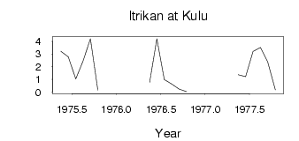
| PointID: | 5866 | Code: | 1099 | Latitude (decimal degrees): | 61.88 | Longitude (decimal degrees): | 147.42 | Drainage Area (km2): | 195.00 | Source: | SHI | Hydrological Zone: | Anadyr Kolyma | Name: | Itrikan at Kulu |
|---|
| Download | |
|---|---|
| Site Descriptor Information | Site Time Series Data |
| Link to all available data | |
| ID | Year | Jan | Feb | Mar | Apr | May | Jun | Jul | Aug | Sep | Oct | Nov | Dec |
|---|---|---|---|---|---|---|---|---|---|---|---|---|---|
| 5866 | 1975 | 3.22 | 2.76 | 1.03 | 2.44 | 4.21 | 0.14 | ||||||
| 5866 | 1976 | 0.76 | 4.21 | 0.98 | 0.63 | 0.23 | 0.02 | ||||||
| 5866 | 1977 | 1.36 | 1.22 | 3.20 | 3.52 | 2.38 | 0.17 |
 Return to R-Arctic Net Home Page