Dolgi' at Kamenistyui'
Anadyr Kolyma
| PointID: | 5860 |
Code: | 1037 |
Latitude (decimal degrees): | 62.95 |
Longitude (decimal degrees): | 147.20 |
Drainage Area (km2): | 166.00 |
Source: | SHI |
Hydrological Zone: | Anadyr Kolyma |
Name: | Dolgi' at Kamenistyui' |
Field Definitions
Site Time Series Plot:
Site Data File:
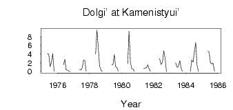
(Units: m3/s)
| ID | Year | Jan | Feb | Mar | Apr | May | Jun | Jul | Aug | Sep | Oct | Nov | Dec |
|---|
| 5860 | 1975 | | | | | 4.13 | 3.95 | 1.13 | 2.13 | 4.13 | 0.07 | | |
| 5860 | 1976 | | | | | 1.57 | 2.84 | 0.38 | 0.32 | 0.11 | 4.0e-03 | | |
| 5860 | 1977 | | | | | 0.43 | 0.38 | 0.83 | 2.63 | 2.54 | 0.06 | | |
| 5860 | 1978 | | | | | 3.95 | 9.52 | 5.55 | 1.26 | 0.39 | 0.01 | | |
| 5860 | 1979 | | | | | 1.62 | 1.57 | 3.90 | 1.17 | 0.92 | 0.08 | | |
| 5860 | 1980 | | | | | 1.77 | 9.29 | 2.34 | 0.67 | 0.68 | 0.01 | | |
| 5860 | 1981 | | | | | 0.69 | 0.83 | 0.84 | 1.58 | 0.68 | 0.04 | | |
| 5860 | 1982 | | | | | 2.97 | 1.63 | 2.13 | 4.79 | 3.11 | 0.03 | | |
| 5860 | 1983 | | | | | 1.98 | 1.00 | 1.10 | 2.54 | 0.76 | 0.04 | | |
| 5860 | 1984 | | | | 0.02 | 2.68 | 2.13 | 4.49 | 6.70 | 1.48 | 0.02 | | |
| 5860 | 1985 | | | | | 4.71 | 4.47 | 2.07 | 1.72 | 1.96 | 0.06 | | |
 Return to R-Arctic Net Home Page