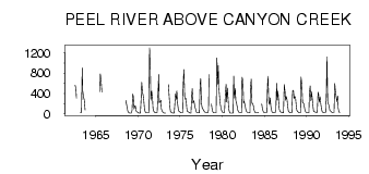
| PointID: | 5847 | Code: | 10MA001 | Latitude (decimal degrees): | 65.89 | Longitude (decimal degrees): | -136.03 | Drainage Area (km2): | 25700.00 | Source: | Hydat | Hydrological Zone: | Mackenzie | Name: | PEEL RIVER ABOVE CANYON CREEK |
|---|
| Download | |
|---|---|
| Site Descriptor Information | Site Time Series Data |
| Link to all available data | |
| ID | Year | Jan | Feb | Mar | Apr | May | Jun | Jul | Aug | Sep | Oct | Nov | Dec |
|---|---|---|---|---|---|---|---|---|---|---|---|---|---|
| 5847 | 1962 | 562.00 | 486.00 | 309.00 | |||||||||
| 5847 | 1963 | 24.00 | 24.00 | 26.00 | 905.00 | 445.00 | 332.00 | 266.00 | 77.80 | ||||
| 5847 | 1965 | 437.00 | 785.00 | 658.00 | 424.00 | ||||||||
| 5847 | 1968 | 266.00 | 190.00 | 138.00 | 50.60 | 26.00 | 20.00 | ||||||
| 5847 | 1969 | 16.00 | 16.00 | 16.00 | 58.00 | 390.00 | 341.00 | 98.30 | 160.00 | 154.00 | 53.40 | 33.00 | 33.00 |
| 5847 | 1970 | 21.00 | 15.00 | 15.00 | 16.00 | 316.00 | 618.00 | 427.00 | 353.00 | 258.00 | 70.20 | 33.00 | 25.00 |
| 5847 | 1971 | 19.00 | 17.00 | 18.00 | 17.00 | 1300.00 | 839.00 | 266.00 | 449.00 | 319.00 | 109.00 | 51.00 | 31.00 |
| 5847 | 1972 | 22.00 | 19.00 | 20.00 | 22.00 | 373.00 | 774.00 | 218.00 | 235.00 | 268.00 | 102.00 | 52.00 | 36.00 |
| 5847 | 1973 | 24.00 | 16.00 | 12.00 | 12.00 | 574.00 | 330.00 | 114.00 | 43.00 | 27.00 | |||
| 5847 | 1974 | 18.00 | 15.00 | 15.00 | 16.00 | 156.00 | 393.00 | 280.00 | 451.00 | 197.00 | 73.90 | 50.00 | 40.00 |
| 5847 | 1975 | 25.00 | 20.00 | 18.00 | 21.00 | 534.00 | 874.00 | 335.00 | 286.00 | 302.00 | 108.00 | 47.00 | 37.00 |
| 5847 | 1976 | 28.00 | 19.00 | 16.00 | 15.00 | 363.00 | 499.00 | 216.00 | 261.00 | 199.00 | 122.00 | 63.00 | 31.00 |
| 5847 | 1977 | 25.00 | 21.00 | 17.00 | 19.00 | 594.00 | 694.00 | 210.00 | 108.00 | 103.00 | 70.20 | 46.00 | 33.00 |
| 5847 | 1978 | 25.00 | 22.00 | 20.00 | 19.00 | 75.90 | 775.00 | 196.00 | 109.00 | 39.00 | 26.00 | ||
| 5847 | 1979 | 21.00 | 17.00 | 19.00 | 21.00 | 1100.00 | 584.00 | 948.00 | 479.00 | 287.00 | 184.00 | 102.00 | 48.00 |
| 5847 | 1980 | 31.00 | 28.00 | 26.00 | 24.00 | 380.00 | 581.00 | 236.00 | 506.00 | 270.00 | 103.00 | 34.00 | 15.00 |
| 5847 | 1981 | 13.00 | 12.00 | 14.00 | 15.00 | 744.00 | 304.00 | 501.00 | 258.00 | 207.00 | 123.00 | 63.00 | 36.00 |
| 5847 | 1982 | 22.00 | 22.00 | 21.00 | 20.00 | 716.00 | 665.00 | 216.00 | 247.00 | 178.00 | 97.90 | 48.00 | 32.00 |
| 5847 | 1983 | 25.00 | 24.00 | 23.00 | 21.00 | 502.00 | 681.00 | 203.00 | 193.00 | 163.00 | 70.20 | 34.00 | 22.00 |
| 5847 | 1984 | 18.00 | 17.00 | 18.00 | 28.00 | 195.00 | 89.40 | 47.00 | 28.00 | ||||
| 5847 | 1985 | 19.00 | 18.00 | 20.00 | 20.00 | 527.00 | 736.00 | 229.00 | 185.00 | 313.00 | 135.00 | 61.00 | 25.00 |
| 5847 | 1986 | 22.00 | 21.00 | 19.00 | 20.00 | 72.90 | 598.00 | 271.00 | 447.00 | 218.00 | 89.70 | 50.00 | 36.00 |
| 5847 | 1987 | 28.00 | 22.00 | 18.00 | 18.00 | 572.00 | 433.00 | 267.00 | 335.00 | 266.00 | 152.00 | 52.00 | 32.00 |
| 5847 | 1988 | 24.00 | 20.00 | 18.00 | 23.00 | 453.00 | 463.00 | 296.00 | 343.00 | 318.00 | 146.00 | 68.00 | 43.00 |
| 5847 | 1989 | 31.00 | 26.00 | 18.00 | 19.00 | 723.00 | 594.00 | 223.00 | 218.00 | 186.00 | 103.00 | 52.00 | 31.00 |
| 5847 | 1990 | 24.00 | 20.00 | 18.00 | 21.00 | 406.00 | 547.00 | 256.00 | 429.00 | 308.00 | 135.00 | 53.00 | 38.00 |
| 5847 | 1991 | 32.00 | 29.00 | 26.00 | 31.00 | 423.00 | 387.00 | 227.00 | 333.00 | 214.00 | 100.00 | 41.00 | 30.00 |
| 5847 | 1992 | 27.00 | 26.00 | 25.00 | 24.00 | 430.00 | 1120.00 | 223.00 | 188.00 | 156.00 | 65.40 | 55.00 | 38.00 |
| 5847 | 1993 | 29.00 | 25.00 | 25.00 | 26.00 | 592.00 | 467.00 | 346.00 | 242.00 | 348.00 | 112.00 | 33.00 | 26.00 |
 Return to R-Arctic Net Home Page