| PointID: | 5841 | Code: | 10AA004 | Latitude (decimal degrees): | 60.20 | Longitude (decimal degrees): | -129.55 | Drainage Area (km2): | 5100.00 | Source: | Hydat | Hydrological Zone: | Mackenzie | Name: | RANCHERIA RIVER NEAR THE MOUTH |
|---|
| Download | |
|---|---|
| Site Descriptor Information | Site Time Series Data |
| Link to all available data | |
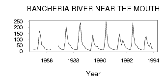
| ID | Year | Jan | Feb | Mar | Apr | May | Jun | Jul | Aug | Sep | Oct | Nov | Dec |
|---|---|---|---|---|---|---|---|---|---|---|---|---|---|
| 5841 | 1985 | 12.00 | 11.00 | 10.00 | 9.00 | 51.70 | 172.00 | 131.00 | 54.70 | 48.40 | 38.30 | 19.00 | 15.00 |
| 5841 | 1986 | 12.00 | 8.00 | 8.00 | 14.00 | 46.00 | 26.00 | ||||||
| 5841 | 1987 | 21.00 | 15.00 | 12.00 | 14.00 | 70.90 | 209.00 | 139.00 | 63.50 | 52.60 | 49.40 | 27.00 | 18.00 |
| 5841 | 1988 | 16.00 | 14.00 | 12.00 | 13.00 | 83.60 | 206.00 | 240.00 | 85.70 | 54.50 | 44.30 | 31.00 | 20.00 |
| 5841 | 1989 | 15.00 | 12.00 | 7.00 | 3.00 | 54.10 | 135.00 | 73.00 | 48.30 | 39.40 | 42.70 | 24.00 | 18.00 |
| 5841 | 1990 | 14.00 | 12.00 | 11.00 | 12.00 | 92.90 | 251.00 | 111.00 | 46.30 | 33.30 | 25.00 | 19.00 | 15.00 |
| 5841 | 1991 | 13.00 | 11.00 | 9.00 | 13.00 | 76.80 | 146.00 | 86.10 | 49.50 | 92.20 | 69.90 | 40.00 | 28.00 |
| 5841 | 1992 | 21.00 | 17.00 | 13.00 | 13.00 | 60.00 | 240.00 | 121.00 | 61.40 | 47.30 | 38.70 | 22.00 | 19.00 |
| 5841 | 1993 | 13.00 | 11.00 | 9.00 | 11.00 | 104.00 | 126.00 | 79.00 | 47.00 | 40.00 | 66.00 | 23.00 | 18.00 |
 Return to R-Arctic Net Home Page