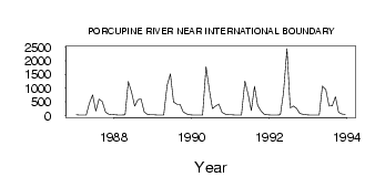
| PointID: | 5838 | Code: | 09FD002 | Latitude (decimal degrees): | 67.42 | Longitude (decimal degrees): | -140.89 | Drainage Area (km2): | 59800.00 | Source: | Hydat | Hydrological Zone: | Yukon | Name: | PORCUPINE RIVER NEAR INTERNATIONAL BOUNDARY |
|---|
| Download | |
|---|---|
| Site Descriptor Information | Site Time Series Data |
| Link to all available data | |
| ID | Year | Jan | Feb | Mar | Apr | May | Jun | Jul | Aug | Sep | Oct | Nov | Dec |
|---|---|---|---|---|---|---|---|---|---|---|---|---|---|
| 5838 | 1987 | 21.00 | 19.00 | 17.00 | 15.00 | 456.00 | 758.00 | 164.00 | 602.00 | 512.00 | 112.00 | 49.00 | 31.00 |
| 5838 | 1988 | 24.00 | 19.00 | 18.00 | 21.00 | 1240.00 | 858.00 | 348.00 | 583.00 | 598.00 | 121.00 | 39.00 | 27.00 |
| 5838 | 1989 | 22.00 | 19.00 | 17.00 | 16.00 | 1110.00 | 1520.00 | 495.00 | 417.00 | 414.00 | 133.00 | 51.00 | 26.00 |
| 5838 | 1990 | 18.00 | 15.00 | 13.00 | 16.00 | 1790.00 | 964.00 | 253.00 | 349.00 | 419.00 | 109.00 | 41.00 | 28.00 |
| 5838 | 1991 | 22.00 | 20.00 | 17.00 | 16.00 | 1260.00 | 771.00 | 184.00 | 1070.00 | 362.00 | 170.00 | 40.00 | 25.00 |
| 5838 | 1992 | 18.00 | 14.00 | 19.00 | 21.00 | 842.00 | 2450.00 | 278.00 | 346.00 | 255.00 | 79.20 | 43.00 | 27.00 |
| 5838 | 1993 | 18.00 | 14.00 | 15.00 | 19.00 | 1080.00 | 942.00 | 345.00 | 361.00 | 687.00 | 116.00 | 57.00 | 37.00 |
 Return to R-Arctic Net Home Page