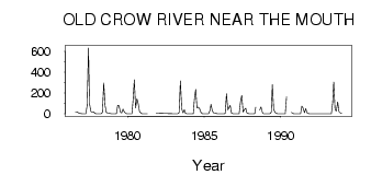
| PointID: | 5836 | Code: | 09FC001 | Latitude (decimal degrees): | 67.63 | Longitude (decimal degrees): | -139.69 | Drainage Area (km2): | 13900.00 | Source: | Hydat | Hydrological Zone: | Yukon | Name: | OLD CROW RIVER NEAR THE MOUTH |
|---|
| Download | |
|---|---|
| Site Descriptor Information | Site Time Series Data |
| Link to all available data | |
| ID | Year | Jan | Feb | Mar | Apr | May | Jun | Jul | Aug | Sep | Oct | Nov | Dec |
|---|---|---|---|---|---|---|---|---|---|---|---|---|---|
| 5836 | 1976 | 18.40 | 19.00 | 10.70 | 6.00 | 3.00 | |||||||
| 5836 | 1977 | 1.00 | 1.00 | 1.00 | 1.00 | 81.40 | 634.00 | 96.30 | 23.10 | 17.20 | 17.60 | 5.00 | 2.00 |
| 5836 | 1978 | 1.00 | 1.00 | 0.00 | 0.00 | 13.80 | 298.00 | 80.30 | 14.00 | 9.35 | 8.03 | 3.00 | 2.00 |
| 5836 | 1979 | 0.00 | 0.00 | 0.00 | 0.00 | 81.20 | 79.10 | 18.40 | 9.49 | 45.20 | 22.90 | 8.00 | 2.00 |
| 5836 | 1980 | 0.00 | 0.00 | 0.00 | 0.00 | 119.00 | 328.00 | 57.00 | 145.00 | 97.60 | 22.20 | 8.00 | 2.00 |
| 5836 | 1981 | 1.00 | 0.00 | 0.00 | 0.00 | 7.00 | 5.00 | ||||||
| 5836 | 1983 | 0.00 | 0.00 | 0.00 | 0.00 | 12.10 | 316.00 | 49.00 | 8.82 | 38.40 | 6.55 | 1.00 | 0.00 |
| 5836 | 1984 | 0.00 | 0.00 | 0.00 | 0.00 | 137.00 | 235.00 | 57.70 | 63.40 | 48.00 | 14.70 | 1.00 | 0.00 |
| 5836 | 1985 | 0.00 | 0.00 | 0.00 | 0.00 | 31.00 | 92.20 | 31.80 | 8.27 | 7.68 | 4.37 | 1.00 | 0.00 |
| 5836 | 1986 | 0.00 | 0.00 | 0.00 | 0.00 | 2.67 | 192.00 | 38.40 | 55.80 | 81.10 | 8.28 | 2.00 | 1.00 |
| 5836 | 1987 | 1.00 | 0.00 | 0.00 | 0.00 | 115.00 | 177.00 | 15.80 | 40.90 | 53.90 | 11.00 | 3.00 | 1.00 |
| 5836 | 1988 | 0.00 | 0.00 | 0.00 | 1.00 | 63.10 | 35.70 | 67.50 | 15.20 | 2.00 | 1.00 | ||
| 5836 | 1989 | 0.00 | 0.00 | 0.00 | 0.00 | 15.10 | 281.00 | 44.10 | 14.20 | 4.67 | 1.73 | 1.00 | 0.00 |
| 5836 | 1990 | 0.00 | 0.00 | 0.00 | 0.00 | 165.00 | 12.30 | 2.51 | 0.00 | 0.00 | |||
| 5836 | 1991 | 0.00 | 0.00 | 0.00 | 0.00 | 74.00 | 53.70 | 11.90 | 52.30 | 11.80 | 2.59 | 0.00 | 0.00 |
| 5836 | 1993 | 0.00 | 0.00 | 0.00 | 0.00 | 106.00 | 306.00 | 41.80 | 25.50 | 115.00 | 21.20 | 9.00 | 3.00 |
| Other Close Sites | ||||||
|---|---|---|---|---|---|---|
| PointID | Latitude | Longitude | Drainage Area | Source | Name | |
| 5837 | 67.56 | -139.88 | 55400.00 | Hydat | PORCUPINE RIVER AT OLD CROW | |
 Return to R-Arctic Net Home Page