| PointID: | 5828 | Code: | 09EB002 | Latitude (decimal degrees): | 63.31 | Longitude (decimal degrees): | -139.42 | Drainage Area (km2): | 251000.00 | Source: | Hydat | Hydrological Zone: | Yukon | Name: | YUKON RIVER AT STEWART RIVER |
|---|
| Download | |
|---|---|
| Site Descriptor Information | Site Time Series Data |
| Link to all available data | |
| ID | Year | Jan | Feb | Mar | Apr | May | Jun | Jul | Aug | Sep | Oct | Nov | Dec |
|---|---|---|---|---|---|---|---|---|---|---|---|---|---|
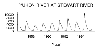
| 5828 | 1956 | 2310.00 | 1400.00 | 584.00 | 436.00 | ||||||||
| 5828 | 1957 | 410.00 | 363.00 | 357.00 | 321.00 | 4230.00 | 6190.00 | 4820.00 | 3210.00 | 2240.00 | 1580.00 | 982.00 | 572.00 |
| 5828 | 1958 | 559.00 | 454.00 | 393.00 | 419.00 | 2020.00 | 3700.00 | 3010.00 | 2730.00 | 1930.00 | 973.00 | ||
| 5828 | 1959 | 375.00 | 352.00 | 372.00 | 3540.00 | 4940.00 | 4020.00 | 3560.00 | 2750.00 | 1570.00 | |||
| 5828 | 1960 | 544.00 | 444.00 | 394.00 | 441.00 | 3290.00 | 4380.00 | 4640.00 | 4410.00 | 3210.00 | 2000.00 | 892.00 | 708.00 |
| 5828 | 1961 | 622.00 | 496.00 | 424.00 | 411.00 | 2790.00 | 6850.00 | 4920.00 | 3830.00 | 2880.00 | 2210.00 | 841.00 | 623.00 |
| 5828 | 1962 | 566.00 | 510.00 | 453.00 | 425.00 | 2970.00 | 8800.00 | 6310.00 | 4510.00 | 3300.00 | 2350.00 | 1130.00 | 757.00 |
| 5828 | 1963 | 664.00 | 582.00 | 524.00 | 460.00 | 3970.00 | 5050.00 | 5880.00 | 4030.00 | 3180.00 | 2450.00 | 1150.00 | 708.00 |
| 5828 | 1964 | 683.00 | 623.00 | 542.00 | 510.00 | 1490.00 | 11000.00 | 6530.00 | 4810.00 | 3040.00 | 1910.00 | 975.00 | 571.00 |
| 5828 | 1965 | 438.00 | 418.00 | 422.00 | 472.00 | 1600.00 |
| Other Close Sites | ||||||
|---|---|---|---|---|---|---|
| PointID | Latitude | Longitude | Drainage Area | Source | Name | |
| 5822 | 63.28 | -139.24 | 51000.00 | Hydat | STEWART RIVER AT THE MOUTH | |
 Return to R-Arctic Net Home Page