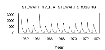
| PointID: | 5821 | Code: | 09DD002 | Latitude (decimal degrees): | 63.38 | Longitude (decimal degrees): | -136.68 | Drainage Area (km2): | 35000.00 | Source: | Hydat | Hydrological Zone: | Yukon | Name: | STEWART RIVER AT STEWART CROSSING |
|---|
| Download | |
|---|---|
| Site Descriptor Information | Site Time Series Data |
| Link to all available data | |
| ID | Year | Jan | Feb | Mar | Apr | May | Jun | Jul | Aug | Sep | Oct | Nov | Dec |
|---|---|---|---|---|---|---|---|---|---|---|---|---|---|
| 5821 | 1961 | 2250.00 | 1060.00 | 741.00 | 402.00 | 231.00 | 88.00 | 68.00 | |||||
| 5821 | 1962 | 62.00 | 57.00 | 53.00 | 53.00 | 731.00 | 2320.00 | 1010.00 | 662.00 | 513.00 | 313.00 | 143.00 | 90.00 |
| 5821 | 1963 | 73.00 | 65.00 | 56.00 | 48.00 | 833.00 | 1290.00 | 1060.00 | 643.00 | 494.00 | 406.00 | 139.00 | 100.00 |
| 5821 | 1964 | 83.00 | 69.00 | 64.00 | 64.00 | 207.00 | 3150.00 | 1500.00 | 993.00 | 577.00 | 308.00 | 154.00 | 101.00 |
| 5821 | 1965 | 66.00 | 50.00 | 47.00 | 52.00 | 345.00 | 1070.00 | 822.00 | 521.00 | 478.00 | 264.00 | 94.00 | 80.00 |
| 5821 | 1966 | 47.00 | 46.00 | 46.00 | 65.00 | 628.00 | 1500.00 | 738.00 | 420.00 | 364.00 | 230.00 | 94.00 | 68.00 |
| 5821 | 1967 | 59.00 | 57.00 | 57.00 | 61.00 | 517.00 | 1630.00 | 789.00 | 695.00 | 690.00 | 275.00 | 149.00 | 103.00 |
| 5821 | 1968 | 80.00 | 68.00 | 68.00 | 79.00 | 809.00 | 1620.00 | 832.00 | 392.00 | 307.00 | 197.00 | 127.00 | 84.00 |
| 5821 | 1969 | 43.00 | 34.00 | 28.00 | 48.00 | 419.00 | 1010.00 | 453.00 | 460.00 | 490.00 | 222.00 | 122.00 | 82.00 |
| 5821 | 1970 | 57.00 | 51.00 | 48.00 | 55.00 | 625.00 | 1570.00 | 1060.00 | 632.00 | 528.00 | 305.00 | 123.00 | 83.00 |
| 5821 | 1971 | 61.00 | 50.00 | 42.00 | 49.00 | 792.00 | 1750.00 | 843.00 | 509.00 | 418.00 | 214.00 | 132.00 | 87.00 |
| 5821 | 1972 | 59.00 | 45.00 | 39.00 | 37.00 | 621.00 | 1760.00 | 732.00 | 478.00 | 500.00 | 203.00 | 108.00 | 89.00 |
| 5821 | 1973 | 55.00 | 46.00 | 47.00 | 56.00 | 853.00 | 1420.00 | 982.00 | 665.00 | 596.00 | 215.00 | 95.00 | 61.00 |
 Return to R-Arctic Net Home Page