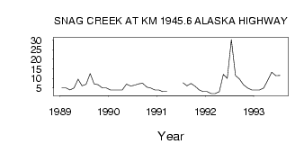
| PointID: | 5815 | Code: | 09CB002 | Latitude (decimal degrees): | 62.47 | Longitude (decimal degrees): | -140.86 | Drainage Area (km2): | 676.00 | Source: | Hydat | Hydrological Zone: | Yukon | Name: | SNAG CREEK AT KM 1945.6 ALASKA HIGHWAY |
|---|
| Download | |
|---|---|
| Site Descriptor Information | Site Time Series Data |
| Link to all available data | |
| ID | Year | Jan | Feb | Mar | Apr | May | Jun | Jul | Aug | Sep | Oct | Nov | Dec |
|---|---|---|---|---|---|---|---|---|---|---|---|---|---|
| 5815 | 1989 | 5.00 | 5.00 | 4.00 | 5.00 | 9.62 | 6.10 | 6.91 | 12.60 | 7.11 | 6.68 | 5.00 | 5.00 |
| 5815 | 1990 | 4.00 | 4.00 | 4.00 | 4.00 | 7.04 | 6.03 | 6.51 | 7.10 | 7.43 | 5.38 | 5.00 | 4.00 |
| 5815 | 1991 | 4.00 | 3.00 | 3.00 | 7.69 | 6.06 | 7.33 | 5.88 | 4.00 | 3.00 | |||
| 5815 | 1992 | 3.00 | 2.00 | 2.00 | 3.00 | 12.10 | 10.00 | 30.40 | 11.60 | 9.76 | 6.65 | 5.00 | 4.00 |
| 5815 | 1993 | 4.00 | 4.00 | 5.00 | 9.00 | 13.20 | 11.40 | 11.50 |
 Return to R-Arctic Net Home Page