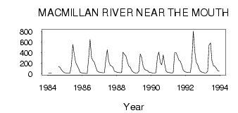
| PointID: | 5805 | Code: | 09BB002 | Latitude (decimal degrees): | 62.89 | Longitude (decimal degrees): | -135.51 | Drainage Area (km2): | 13800.00 | Source: | Hydat | Hydrological Zone: | Yukon | Name: | MACMILLAN RIVER NEAR THE MOUTH |
|---|
| Download | |
|---|---|
| Site Descriptor Information | Site Time Series Data |
| Link to all available data | |
| ID | Year | Jan | Feb | Mar | Apr | May | Jun | Jul | Aug | Sep | Oct | Nov | Dec |
|---|---|---|---|---|---|---|---|---|---|---|---|---|---|
| 5805 | 1984 | 12.00 | 13.00 | 15.00 | 137.00 | 122.00 | 76.30 | 44.00 | 21.00 | ||||
| 5805 | 1985 | 15.00 | 11.00 | 10.00 | 14.00 | 165.00 | 556.00 | 360.00 | 216.00 | 154.00 | 102.00 | 28.00 | 18.00 |
| 5805 | 1986 | 13.00 | 8.00 | 5.00 | 6.00 | 303.00 | 646.00 | 302.00 | 251.00 | 222.00 | 126.00 | 54.00 | 36.00 |
| 5805 | 1987 | 25.00 | 23.00 | 18.00 | 19.00 | 254.00 | 455.00 | 240.00 | 159.00 | 147.00 | 121.00 | 49.00 | 37.00 |
| 5805 | 1988 | 26.00 | 21.00 | 19.00 | 25.00 | 406.00 | 365.00 | 341.00 | 227.00 | 148.00 | 123.00 | 64.00 | 32.00 |
| 5805 | 1989 | 20.00 | 14.00 | 12.00 | 45.00 | 376.00 | 311.00 | 144.00 | 84.70 | 67.40 | 59.10 | 33.00 | 26.00 |
| 5805 | 1990 | 18.00 | 13.00 | 13.00 | 21.00 | 326.00 | 411.00 | 211.00 | 169.00 | 357.00 | 189.00 | 50.00 | 28.00 |
| 5805 | 1991 | 21.00 | 19.00 | 17.00 | 23.00 | 399.00 | 402.00 | 328.00 | 255.00 | 238.00 | 160.00 | 73.00 | 39.00 |
| 5805 | 1992 | 31.00 | 25.00 | 22.00 | 29.00 | 229.00 | 809.00 | 438.00 | 217.00 | 178.00 | 91.80 | 44.00 | 31.00 |
| 5805 | 1993 | 21.00 | 17.00 | 17.00 | 48.00 | 541.00 | 583.00 | 254.00 | 155.00 | 141.00 | 105.00 | 59.00 | 47.00 |
 Return to R-Arctic Net Home Page