| PointID: | 5803 | Code: | 09BA002 | Latitude (decimal degrees): | 62.03 | Longitude (decimal degrees): | -130.60 | Drainage Area (km2): | 5020.00 | Source: | Hydat | Hydrological Zone: | Yukon | Name: | PELLY RIVER BELOW FORTIN CREEK |
|---|
| Download | |
|---|---|
| Site Descriptor Information | Site Time Series Data |
| Link to all available data | |
| ID | Year | Jan | Feb | Mar | Apr | May | Jun | Jul | Aug | Sep | Oct | Nov | Dec |
|---|---|---|---|---|---|---|---|---|---|---|---|---|---|
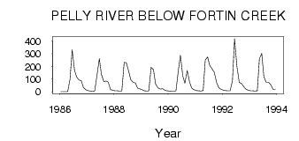
| 5803 | 1986 | 1.00 | 1.00 | 1.00 | 1.00 | 100.00 | 331.00 | 171.00 | 116.00 | 93.30 | 88.00 | 34.00 | 16.00 |
| 5803 | 1987 | 10.00 | 7.00 | 5.00 | 7.00 | 130.00 | 261.00 | 136.00 | 80.70 | 85.40 | 76.40 | 16.00 | 13.00 |
| 5803 | 1988 | 9.00 | 8.00 | 7.00 | 7.00 | 231.00 | 229.00 | 163.00 | 95.60 | 75.50 | 69.10 | 30.00 | 23.00 |
| 5803 | 1989 | 16.00 | 8.00 | 6.00 | 9.00 | 193.00 | 175.00 | 62.00 | 32.00 | 21.70 | 24.30 | 13.00 | 9.00 |
| 5803 | 1990 | 7.00 | 5.00 | 5.00 | 8.00 | 167.00 | 287.00 | 125.00 | 67.80 | 168.00 | 78.10 | 29.00 | 17.00 |
| 5803 | 1991 | 10.00 | 8.00 | 6.00 | 10.00 | 250.00 | 275.00 | 208.00 | 181.00 | 152.00 | 74.40 | 31.00 | 20.00 |
| 5803 | 1992 | 13.00 | 10.00 | 9.00 | 8.00 | 86.40 | 418.00 | 202.00 | 75.10 | 66.80 | 41.10 | 21.00 | 13.00 |
| 5803 | 1993 | 9.00 | 8.00 | 7.00 | 8.00 | 260.00 | 302.00 | 119.00 | 74.70 | 74.70 | 58.20 | 20.00 | 19.00 |
 Return to R-Arctic Net Home Page