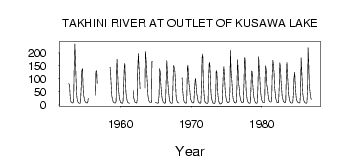
| PointID: | 5791 | Code: | 09AC004 | Latitude (decimal degrees): | 60.61 | Longitude (decimal degrees): | -136.12 | Drainage Area (km2): | 4070.00 | Source: | Hydat | Hydrological Zone: | Yukon | Name: | TAKHINI RIVER AT OUTLET OF KUSAWA LAKE |
|---|
| Download | |
|---|---|
| Site Descriptor Information | Site Time Series Data |
| Link to all available data | |
| ID | Year | Jan | Feb | Mar | Apr | May | Jun | Jul | Aug | Sep | Oct | Nov | Dec |
|---|---|---|---|---|---|---|---|---|---|---|---|---|---|
| 5791 | 1952 | 81.70 | 75.40 | 41.00 | 18.00 | ||||||||
| 5791 | 1953 | 9.00 | 9.00 | 8.00 | 7.00 | 14.30 | 123.00 | 234.00 | 187.00 | 102.00 | 47.70 | 25.00 | 13.00 |
| 5791 | 1954 | 9.00 | 7.00 | 6.00 | 6.00 | 17.40 | 77.90 | 131.00 | 140.00 | 80.10 | 41.80 | 25.00 | 16.00 |
| 5791 | 1955 | 12.00 | 9.00 | 8.00 | 7.00 | 11.10 | 25.70 | 40.00 | |||||
| 5791 | 1956 | 4.00 | 37.70 | 129.00 | 131.00 | 82.90 | |||||||
| 5791 | 1958 | 144.00 | 119.00 | 67.50 | 34.50 | 20.00 | 13.00 | ||||||
| 5791 | 1959 | 9.00 | 8.00 | 7.00 | 7.00 | 12.40 | 127.00 | 175.00 | 110.00 | 66.00 | 40.40 | 22.00 | 15.00 |
| 5791 | 1960 | 9.00 | 8.00 | 6.00 | 6.00 | 15.10 | 68.90 | 146.00 | 160.00 | 82.30 | 45.60 | 25.00 | 15.00 |
| 5791 | 1961 | 9.00 | 7.00 | 7.00 | 6.00 | 55.00 | 28.00 | 17.00 | |||||
| 5791 | 1962 | 12.00 | 8.00 | 8.00 | 7.00 | 19.50 | 131.00 | 197.00 | 155.00 | 101.00 | 62.30 | ||
| 5791 | 1963 | 64.60 | 204.00 | 166.00 | 127.00 | 79.20 | 38.00 | 19.00 | |||||
| 5791 | 1964 | 14.00 | 11.00 | 10.00 | 9.00 | 9.29 | 166.00 | 166.00 | 9.00 | ||||
| 5791 | 1965 | 8.00 | 8.00 | 7.00 | 6.00 | 7.64 | 38.20 | 139.00 | 126.00 | 84.50 | 48.10 | 28.00 | 17.00 |
| 5791 | 1966 | 11.00 | 9.00 | 6.00 | 6.00 | 8.95 | 76.20 | 170.00 | 134.00 | 80.20 | 55.60 | 29.00 | 15.00 |
| 5791 | 1967 | 9.00 | 7.00 | 6.00 | 6.00 | 11.00 | 121.00 | 152.00 | 137.00 | 127.00 | 74.90 | 33.00 | 18.00 |
| 5791 | 1968 | 10.00 | 8.00 | 8.00 | 7.00 | 104.00 | 59.20 | 29.00 | 17.00 | ||||
| 5791 | 1969 | 11.00 | 9.00 | 7.00 | 6.00 | 11.80 | 143.00 | 152.00 | 104.00 | 78.80 | 56.20 | 34.00 | 21.00 |
| 5791 | 1970 | 13.00 | 10.00 | 8.00 | 7.00 | 10.30 | 48.40 | 92.90 | 101.00 | 66.50 | 43.60 | 27.00 | 16.00 |
| 5791 | 1971 | 10.00 | 8.00 | 7.00 | 6.00 | 7.58 | 64.30 | 180.00 | 195.00 | 96.20 | 45.30 | 22.00 | 12.00 |
| 5791 | 1972 | 8.00 | 7.00 | 6.00 | 5.00 | 9.26 | 98.80 | 163.00 | 160.00 | 101.00 | 48.80 | 27.00 | 16.00 |
| 5791 | 1973 | 8.00 | 7.00 | 6.00 | 5.00 | 8.31 | 40.10 | 131.00 | 124.00 | 73.60 | 39.20 | 18.00 | 9.00 |
| 5791 | 1974 | 4.00 | 3.00 | 4.00 | 5.00 | 10.20 | 57.20 | 127.00 | 146.00 | 121.00 | 64.50 | 37.00 | 23.00 |
| 5791 | 1975 | 14.00 | 8.00 | 8.00 | 8.00 | 12.40 | 50.10 | 209.00 | 128.00 | 109.00 | 80.70 | 35.00 | 21.00 |
| 5791 | 1976 | 13.00 | 9.00 | 8.00 | 7.00 | 10.70 | 60.20 | 173.00 | 136.00 | 82.20 | 65.30 | 37.00 | 24.00 |
| 5791 | 1977 | 15.00 | 10.00 | 8.00 | 8.00 | 11.30 | 91.70 | 181.00 | 179.00 | 103.00 | 51.00 | 27.00 | 15.00 |
| 5791 | 1978 | 10.00 | 8.00 | 6.00 | 6.00 | 9.80 | 76.30 | 130.00 | 127.00 | 82.60 | 45.90 | 29.00 | 18.00 |
| 5791 | 1979 | 11.00 | 7.00 | 6.00 | 6.00 | 15.00 | 74.00 | 185.00 | 144.00 | 103.00 | 62.60 | 35.00 | 20.00 |
| 5791 | 1980 | 14.00 | 10.00 | 9.00 | 8.00 | 11.90 | 106.00 | 150.00 | 130.00 | 73.10 | 61.90 | 38.00 | 21.00 |
| 5791 | 1981 | 14.00 | 12.00 | 11.00 | 11.00 | 21.50 | 109.00 | 171.00 | 156.00 | 123.00 | 70.50 | 44.00 | 25.00 |
| 5791 | 1982 | 15.00 | 10.00 | 9.00 | 8.00 | 9.38 | 79.00 | 162.00 | 144.00 | 95.70 | 59.60 | 34.00 | 21.00 |
| 5791 | 1983 | 13.00 | 11.00 | 9.00 | 8.00 | 14.40 | 95.80 | 164.00 | 122.00 | 75.20 | 40.00 | 22.00 | 13.00 |
| 5791 | 1984 | 9.00 | 7.00 | 7.00 | 7.00 | 10.40 | 49.10 | 106.00 | 125.00 | 79.60 | 40.30 | 21.00 | 14.00 |
| 5791 | 1985 | 11.00 | 9.00 | 8.00 | 7.00 | 9.54 | 44.60 | 180.00 | 138.00 | 77.20 | 41.30 | 21.00 | 14.00 |
| 5791 | 1986 | 10.00 | 7.00 | 7.00 | 6.00 | 8.87 | 62.30 | 219.00 | 150.00 | 77.30 | 49.70 | 33.00 | 21.00 |
 Return to R-Arctic Net Home Page