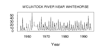
| PointID: | 5788 | Code: | 09AB008 | Latitude (decimal degrees): | 60.61 | Longitude (decimal degrees): | -134.45 | Drainage Area (km2): | 1700.00 | Source: | Hydat | Hydrological Zone: | Yukon | Name: | M'CLINTOCK RIVER NEAR WHITEHORSE |
|---|
| Download | |
|---|---|
| Site Descriptor Information | Site Time Series Data |
| Link to all available data | |
| ID | Year | Jan | Feb | Mar | Apr | May | Jun | Jul | Aug | Sep | Oct | Nov | Dec |
|---|---|---|---|---|---|---|---|---|---|---|---|---|---|
| 5788 | 1956 | 2.00 | 1.00 | 2.00 | 16.60 | 15.00 | 9.05 | 5.37 | 6.46 | 5.59 | 3.00 | 2.00 | |
| 5788 | 1957 | 2.00 | 2.00 | 1.00 | 4.00 | 42.00 | 30.90 | 13.80 | 9.61 | 7.27 | 6.29 | 7.00 | 3.00 |
| 5788 | 1958 | 2.00 | 2.00 | 2.00 | 2.00 | 11.30 | 9.66 | 3.34 | 3.09 | 3.94 | |||
| 5788 | 1959 | 2.00 | 1.00 | 1.00 | 1.00 | 24.50 | 9.09 | 13.10 | 12.70 | 7.01 | 3.00 | 3.00 | |
| 5788 | 1960 | 2.00 | 2.00 | 2.00 | 21.80 | 11.50 | 11.20 | 11.20 | 8.42 | 5.00 | 3.00 | ||
| 5788 | 1961 | 3.00 | 2.00 | 2.00 | 2.00 | 33.70 | 18.80 | 18.20 | 18.10 | 12.70 | 5.00 | 4.00 | |
| 5788 | 1962 | 3.00 | 3.00 | 3.00 | 3.00 | 16.20 | 57.00 | 22.40 | 11.20 | 10.60 | |||
| 5788 | 1963 | 28.50 | 27.80 | 14.40 | 15.70 | 17.00 | |||||||
| 5788 | 1964 | 16.70 | 12.30 | ||||||||||
| 5788 | 1965 | 12.10 | 21.50 | 10.70 | 5.35 | 6.02 | 6.31 | 3.00 | 3.00 | ||||
| 5788 | 1966 | 2.00 | 2.00 | 2.00 | 4.00 | 11.70 | 29.20 | 13.00 | 12.60 | 12.90 | 11.60 | 7.00 | 5.00 |
| 5788 | 1967 | 4.00 | 3.00 | 3.00 | 3.00 | 24.30 | 44.60 | 17.10 | 13.90 | 12.70 | 8.22 | 5.00 | 3.00 |
| 5788 | 1968 | 3.00 | 3.00 | 3.00 | 3.00 | 21.40 | 19.20 | 12.30 | 13.30 | 16.30 | 12.90 | 5.00 | 3.00 |
| 5788 | 1969 | 2.00 | 3.00 | 3.00 | 3.00 | 23.20 | 28.00 | 18.00 | 19.00 | 19.40 | 12.10 | 7.00 | 5.00 |
| 5788 | 1970 | 3.00 | 3.00 | 3.00 | 3.00 | 15.60 | 13.40 | 8.28 | 6.82 | 9.75 | 9.79 | 5.00 | 3.00 |
| 5788 | 1971 | 3.00 | 3.00 | 3.00 | 3.00 | 10.40 | 32.10 | 12.30 | 9.18 | 8.08 | 6.16 | 3.00 | 3.00 |
| 5788 | 1972 | 2.00 | 2.00 | 1.00 | 2.00 | 20.20 | 44.30 | 12.30 | 13.30 | 9.76 | 7.71 | 5.00 | 4.00 |
| 5788 | 1973 | 3.00 | 2.00 | 2.00 | 2.00 | 16.70 | 31.30 | 16.60 | 11.10 | 12.30 | 8.20 | 3.00 | 2.00 |
| 5788 | 1974 | 2.00 | 2.00 | 2.00 | 2.00 | 22.20 | 25.70 | 14.20 | 18.40 | 12.90 | 10.20 | 5.00 | 4.00 |
| 5788 | 1975 | 3.00 | 2.00 | 2.00 | 3.00 | 20.10 | 25.60 | 20.50 | 6.00 | 4.00 | |||
| 5788 | 1976 | 3.00 | 3.00 | 3.00 | 3.00 | 17.50 | 36.20 | 16.60 | 9.70 | 8.52 | 6.94 | 4.00 | 3.00 |
| 5788 | 1977 | 3.00 | 3.00 | 3.00 | 3.00 | 13.10 | 28.80 | 20.30 | 11.80 | 10.90 | 10.70 | 5.00 | 3.00 |
| 5788 | 1978 | 2.00 | 2.00 | 2.00 | 2.00 | 13.60 | 17.80 | 7.52 | 4.00 | 2.00 | |||
| 5788 | 1979 | 2.00 | 2.00 | 2.00 | 3.00 | 18.80 | 25.40 | 25.50 | 11.80 | 9.75 | 9.15 | 6.00 | 4.00 |
| 5788 | 1980 | 3.00 | 3.00 | 2.00 | 3.00 | 13.60 | 16.70 | 9.42 | 10.20 | 14.40 | 16.90 | 9.00 | 4.00 |
| 5788 | 1981 | 4.00 | 4.00 | 4.00 | 4.00 | 26.70 | 19.80 | 17.70 | 9.34 | 9.77 | 9.68 | 6.00 | 4.00 |
| 5788 | 1982 | 2.00 | 2.00 | 2.00 | 1.00 | 12.30 | 32.80 | 9.66 | 7.36 | 7.29 | 7.35 | 5.00 | 3.00 |
| 5788 | 1983 | 3.00 | 3.00 | 3.00 | 3.00 | 15.00 | 20.20 | 12.40 | 7.56 | 10.20 | 8.15 | 3.00 | 2.00 |
| 5788 | 1984 | 2.00 | 2.00 | 3.00 | 2.00 | 14.00 | 19.10 | 9.35 | 9.43 | 9.37 | 7.05 | 4.00 | 3.00 |
| 5788 | 1985 | 3.00 | 2.00 | 2.00 | 3.00 | 16.00 | 31.60 | 20.30 | 9.65 | 8.66 | 7.16 | 3.00 | 3.00 |
| 5788 | 1986 | 3.00 | 2.00 | 2.00 | 3.00 | 10.90 | 32.90 | 22.00 | 14.20 | 11.70 | 14.60 | 7.00 | 4.00 |
| 5788 | 1987 | 3.00 | 3.00 | 3.00 | 4.00 | 15.30 | 27.80 | 13.50 | 7.92 | 7.12 | 7.50 | 5.00 | 3.00 |
| 5788 | 1988 | 2.00 | 2.00 | 2.00 | 3.00 | 22.40 | 24.10 | 32.70 | 19.20 | 11.90 | 11.10 | 8.00 | 5.00 |
| 5788 | 1989 | 3.00 | 3.00 | 3.00 | 7.00 | 20.40 | 13.30 | 8.79 | 5.12 | 5.21 | 6.57 | 4.00 | 3.00 |
| 5788 | 1990 | 2.00 | 2.00 | 2.00 | 3.00 | 18.60 | 27.20 | 14.20 | 6.92 | 6.23 | 5.69 | 3.00 | 3.00 |
| 5788 | 1991 | 2.00 | 2.00 | 2.00 | 2.00 | 19.20 | 21.20 | 16.70 | 16.60 | 27.20 | 19.60 | 10.00 | 7.00 |
| 5788 | 1992 | 6.00 | 5.00 | 5.00 | 6.00 | 20.70 | 47.50 | 23.70 | 13.30 | 12.50 | 11.20 | 9.00 | 6.00 |
| 5788 | 1993 | 4.00 | 3.00 | 3.00 | 3.00 | 22.50 | 23.70 | 15.00 | 9.92 | 10.10 | 11.00 | 6.00 | 3.00 |
 Return to R-Arctic Net Home Page