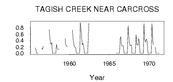
| PointID: | 5785 | Code: | 09AA011 | Latitude (decimal degrees): | 60.29 | Longitude (decimal degrees): | -134.30 | Drainage Area (km2): | 76.90 | Source: | Hydat | Hydrological Zone: | Yukon | Name: | TAGISH CREEK NEAR CARCROSS |
|---|
| Download | |
|---|---|
| Site Descriptor Information | Site Time Series Data |
| Link to all available data | |
| ID | Year | Jan | Feb | Mar | Apr | May | Jun | Jul | Aug | Sep | Oct | Nov | Dec |
|---|---|---|---|---|---|---|---|---|---|---|---|---|---|
| 5785 | 1955 | 0.17 | 0.13 | 0.00 | 0.00 | ||||||||
| 5785 | 1956 | 0.00 | 0.16 | 0.12 | 0.22 | ||||||||
| 5785 | 1957 | 0.74 | 0.49 | 0.32 | 0.28 | 0.34 | 0.00 | 0.00 | |||||
| 5785 | 1958 | 0.00 | 0.00 | 0.00 | 0.00 | 0.28 | 0.16 | 0.12 | 0.12 | 0.14 | |||
| 5785 | 1959 | 0.47 | 0.27 | 0.24 | 0.20 | ||||||||
| 5785 | 1960 | 0.73 | 0.46 | 0.32 | 0.20 | 0.20 | 0.17 | 0.00 | 0.00 | ||||
| 5785 | 1961 | 0.00 | 0.00 | 0.00 | 0.00 | 0.96 | 0.73 | 0.48 | 0.26 | 0.31 | 0.24 | 0.00 | 0.00 |
| 5785 | 1962 | 0.00 | 0.00 | 0.00 | 0.00 | 0.51 | 0.94 | ||||||
| 5785 | 1965 | 0.00 | 0.00 | ||||||||||
| 5785 | 1966 | 0.00 | 0.00 | 0.00 | 0.00 | 0.44 | 0.52 | 0.26 | 0.23 | 0.24 | 0.22 | 0.00 | 0.00 |
| 5785 | 1967 | 0.00 | 0.00 | 0.00 | 0.00 | 0.86 | 0.57 | 0.34 | 0.24 | 0.24 | 0.26 | 0.00 | 0.00 |
| 5785 | 1968 | 0.00 | 0.00 | 0.00 | 0.00 | 0.58 | 0.28 | 0.27 | 0.25 | 0.46 | 0.36 | 0.00 | 0.00 |
| 5785 | 1969 | 0.00 | 0.00 | 0.00 | 0.00 | 0.93 | 0.44 | 0.35 | 0.41 | 0.44 | 0.33 | 0.00 | 0.00 |
| 5785 | 1970 | 0.00 | 0.00 | 0.00 | 0.00 | 0.92 | 0.47 | 0.27 | 0.19 | 0.00 | 0.00 | ||
| 5785 | 1971 | 0.00 | 0.00 | 0.00 | 0.00 |
 Return to R-Arctic Net Home Page