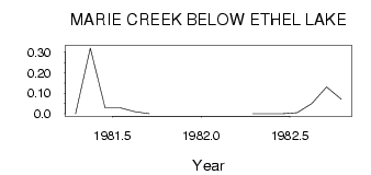
| PointID: | 577 | Code: | 06AC901 | Latitude (decimal degrees): | 54.52 | Longitude (decimal degrees): | -110.32 | Drainage Area (km2): | 595.00 | Source: | Hydat | Hydrological Zone: | Northwest Hudson Bay | Name: | MARIE CREEK BELOW ETHEL LAKE |
|---|
| Download | |
|---|---|
| Site Descriptor Information | Site Time Series Data |
| Link to all available data | |
| ID | Year | Jan | Feb | Mar | Apr | May | Jun | Jul | Aug | Sep | Oct | Nov | Dec |
|---|---|---|---|---|---|---|---|---|---|---|---|---|---|
| 577 | 1981 | 0.00 | 0.32 | 0.03 | 0.03 | 0.01 | 1.0e-03 | ||||||
| 577 | 1982 | 0.00 | 0.00 | 1.0e-03 | 6.0e-03 | 0.05 | 0.13 | 0.07 |
 Return to R-Arctic Net Home Page