| PointID: | 573 | Code: | 06AB003 | Latitude (decimal degrees): | 54.53 | Longitude (decimal degrees): | -111.22 | Drainage Area (km2): | 395.00 | Source: | Hydat | Hydrological Zone: | Northwest Hudson Bay | Name: | PUNK CREEK NEAR THE MOUTH |
|---|
| Download | |
|---|---|
| Site Descriptor Information | Site Time Series Data |
| Link to all available data | |
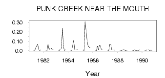
| ID | Year | Jan | Feb | Mar | Apr | May | Jun | Jul | Aug | Sep | Oct | Nov | Dec |
|---|---|---|---|---|---|---|---|---|---|---|---|---|---|
| 573 | 1981 | 0.00 | 0.00 | 0.03 | 0.05 | 0.07 | 0.01 | 3.0e-03 | 0.01 | ||||
| 573 | 1982 | 0.00 | 0.00 | 0.07 | 0.01 | 0.03 | 0.03 | 0.01 | 0.01 | ||||
| 573 | 1983 | 0.00 | 0.00 | 0.02 | 0.02 | 0.24 | 0.04 | 3.0e-03 | 0.01 | ||||
| 573 | 1984 | 0.00 | 0.00 | 0.06 | 0.11 | 0.01 | 8.0e-03 | 0.01 | 0.01 | ||||
| 573 | 1985 | 0.00 | 0.00 | 0.31 | 0.21 | 0.10 | 0.05 | 0.04 | 0.03 | ||||
| 573 | 1986 | 0.00 | 0.00 | 0.05 | 0.01 | 0.06 | 0.05 | 6.0e-03 | 0.01 | ||||
| 573 | 1987 | 0.00 | 0.00 | 0.07 | 0.07 | 0.01 | 9.0e-03 | 9.0e-03 | 5.0e-03 | ||||
| 573 | 1988 | 0.00 | 0.00 | 5.0e-03 | 0.01 | 0.01 | 4.0e-03 | 0.00 | 1.0e-03 | ||||
| 573 | 1989 | 0.00 | 0.00 | 0.01 | 5.0e-03 | 2.0e-03 | 1.0e-03 | 1.0e-03 | 0.01 | ||||
| 573 | 1990 | 0.00 | 0.00 | 0.01 | 6.0e-03 | 0.01 | 2.0e-03 | 8.0e-03 | 4.0e-03 |
 Return to R-Arctic Net Home Page