| PointID: | 5615 | Code: | 07LE002 | Latitude (decimal degrees): | 59.14 | Longitude (decimal degrees): | -105.53 | Drainage Area (km2): | 50700.00 | Source: | Hydat | Hydrological Zone: | Mackenzie | Name: | FOND DU LAC RIVER AT OUTLET OF BLACK LAKE |
|---|
| Download | |
|---|---|
| Site Descriptor Information | Site Time Series Data |
| Link to all available data | |
| ID | Year | Jan | Feb | Mar | Apr | May | Jun | Jul | Aug | Sep | Oct | Nov | Dec |
|---|---|---|---|---|---|---|---|---|---|---|---|---|---|
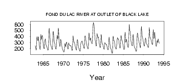
| 5615 | 1963 | 246.00 | 227.00 | 207.00 | 176.00 | 315.00 | 398.00 | 365.00 | 337.00 | 333.00 | 398.00 | 384.00 | 320.00 |
| 5615 | 1964 | 260.00 | 223.00 | 198.00 | 188.00 | 357.00 | 433.00 | 351.00 | 373.00 | 395.00 | 419.00 | 390.00 | 318.00 |
| 5615 | 1965 | 265.00 | 229.00 | 205.00 | 203.00 | 311.00 | 336.00 | 364.00 | 326.00 | 272.00 | 253.00 | 239.00 | 228.00 |
| 5615 | 1966 | 210.00 | 187.00 | 176.00 | 186.00 | 276.00 | 506.00 | 536.00 | 460.00 | 393.00 | 319.00 | 272.00 | 249.00 |
| 5615 | 1967 | 233.00 | 214.00 | 195.00 | 189.00 | 240.00 | 471.00 | 485.00 | 433.00 | 367.00 | 322.00 | 292.00 | 266.00 |
| 5615 | 1968 | 230.00 | 203.00 | 195.00 | 207.00 | 291.00 | 415.00 | 413.00 | 370.00 | 355.00 | 538.00 | 495.00 | 380.00 |
| 5615 | 1969 | 297.00 | 241.00 | 239.00 | 267.00 | 358.00 | 332.00 | 304.00 | 266.00 | 226.00 | 208.00 | 187.00 | 174.00 |
| 5615 | 1970 | 162.00 | 148.00 | 148.00 | 156.00 | 240.00 | 287.00 | 252.00 | 232.00 | 272.00 | 304.00 | 309.00 | 272.00 |
| 5615 | 1971 | 240.00 | 207.00 | 195.00 | 208.00 | 296.00 | 275.00 | 264.00 | 254.00 | 248.00 | 250.00 | 255.00 | 249.00 |
| 5615 | 1972 | 221.00 | 190.00 | 172.00 | 176.00 | 302.00 | 413.00 | 376.00 | 330.00 | 301.00 | 304.00 | 287.00 | 255.00 |
| 5615 | 1973 | 226.00 | 208.00 | 192.00 | 177.00 | 201.00 | 315.00 | 351.00 | 335.00 | 281.00 | 245.00 | 219.00 | 201.00 |
| 5615 | 1974 | 182.00 | 165.00 | 159.00 | 173.00 | 269.00 | 303.00 | 311.00 | 319.00 | 328.00 | 316.00 | 288.00 | 263.00 |
| 5615 | 1975 | 253.00 | 222.00 | 209.00 | 208.00 | 381.00 | 412.00 | 405.00 | 363.00 | 322.00 | 288.00 | 269.00 | 240.00 |
| 5615 | 1976 | 222.00 | 207.00 | 197.00 | 233.00 | 412.00 | 460.00 | 391.00 | 348.00 | 339.00 | 370.00 | 377.00 | 332.00 |
| 5615 | 1977 | 303.00 | 287.00 | 283.00 | 287.00 | 466.00 | 598.00 | 630.00 | 607.00 | 584.00 | 510.00 | 432.00 | 355.00 |
| 5615 | 1978 | 311.00 | 273.00 | 244.00 | 248.00 | 368.00 | 450.00 | 419.00 | 397.00 | 382.00 | 393.00 | 356.00 | 305.00 |
| 5615 | 1979 | 271.00 | 238.00 | 220.00 | 225.00 | 287.00 | 435.00 | 403.00 | 324.00 | 279.00 | 276.00 | 276.00 | 249.00 |
| 5615 | 1980 | 228.00 | 203.00 | 191.00 | 216.00 | 298.00 | 292.00 | 285.00 | 279.00 | 268.00 | 272.00 | 262.00 | 228.00 |
| 5615 | 1981 | 198.00 | 187.00 | 182.00 | 199.00 | 319.00 | 391.00 | 340.00 | 298.00 | 250.00 | 217.00 | 199.00 | 192.00 |
| 5615 | 1982 | 163.00 | 133.00 | 125.00 | 128.00 | 274.00 | 407.00 | 376.00 | 332.00 | 331.00 | 322.00 | 269.00 | 234.00 |
| 5615 | 1983 | 217.00 | 200.00 | 195.00 | 211.00 | 277.00 | 349.00 | 381.00 | 369.00 | 358.00 | 359.00 | 340.00 | 289.00 |
| 5615 | 1984 | 249.00 | 222.00 | 211.00 | 240.00 | 393.00 | 418.00 | 379.00 | 344.00 | 330.00 | 313.00 | 278.00 | 255.00 |
| 5615 | 1985 | 215.00 | 192.00 | 188.00 | 203.00 | 406.00 | 473.00 | 370.00 | 305.00 | 315.00 | 357.00 | 334.00 | 288.00 |
| 5615 | 1986 | 250.00 | 234.00 | 221.00 | 236.00 | 401.00 | 600.00 | 545.00 | 494.00 | 484.00 | 428.00 | 351.00 | 303.00 |
| 5615 | 1987 | 279.00 | 258.00 | 248.00 | 256.00 | 407.00 | 435.00 | 380.00 | 289.00 | 245.00 | 223.00 | 214.00 | 203.00 |
| 5615 | 1988 | 185.00 | 161.00 | 158.00 | 169.00 | 269.00 | 438.00 | 458.00 | 423.00 | 383.00 | 350.00 | 317.00 | 300.00 |
| 5615 | 1989 | 270.00 | 245.00 | 225.00 | 217.00 | 371.00 | 526.00 | 567.00 | 472.00 | 407.00 | 391.00 | 356.00 | 326.00 |
| 5615 | 1990 | 291.00 | 262.00 | 242.00 | 247.00 | 307.00 | 348.00 | 377.00 | 354.00 | 308.00 | 286.00 | 273.00 | 269.00 |
| 5615 | 1991 | 249.00 | 234.00 | 219.00 | 235.00 | 370.00 | 546.00 | 487.00 | 402.00 | 381.00 | 372.00 | 353.00 | 335.00 |
| 5615 | 1992 | 311.00 | 285.00 | 270.00 | 269.00 | 416.00 | 516.00 | 427.00 | 363.00 | 387.00 | 471.00 | 459.00 | 372.00 |
| 5615 | 1993 | 297.00 | 255.00 | 239.00 | 261.00 | 332.00 | 333.00 | 298.00 | 340.00 | 361.00 | 329.00 | 308.00 | 288.00 |
| Other Close Sites | ||||||
|---|---|---|---|---|---|---|
| PointID | Latitude | Longitude | Drainage Area | Source | Name | |
| 5614 | 59.26 | -105.80 | 51800.00 | Hydat | FOND DU LAC RIVER AT STONY RAPIDS | |
 Return to R-Arctic Net Home Page