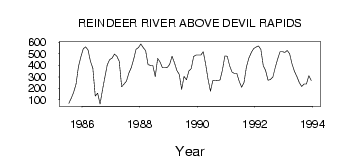
| PointID: | 5601 | Code: | 06DD002 | Latitude (decimal degrees): | 56.19 | Longitude (decimal degrees): | -103.15 | Drainage Area (km2): | 63300.00 | Source: | Hydat | Hydrological Zone: | Northwest Hudson Bay | Name: | REINDEER RIVER ABOVE DEVIL RAPIDS |
|---|
| Download | |
|---|---|
| Site Descriptor Information | Site Time Series Data |
| Link to all available data | |
| ID | Year | Jan | Feb | Mar | Apr | May | Jun | Jul | Aug | Sep | Oct | Nov | Dec |
|---|---|---|---|---|---|---|---|---|---|---|---|---|---|
| 5601 | 1985 | 69.90 | 114.00 | 166.00 | 237.00 | 390.00 | 473.00 | ||||||
| 5601 | 1986 | 544.00 | 560.00 | 534.00 | 434.00 | 374.00 | 133.00 | 157.00 | 62.50 | 185.00 | 295.00 | 403.00 | 449.00 |
| 5601 | 1987 | 462.00 | 497.00 | 478.00 | 434.00 | 214.00 | 236.00 | 262.00 | 332.00 | 378.00 | 451.00 | 540.00 | 554.00 |
| 5601 | 1988 | 586.00 | 554.00 | 527.00 | 406.00 | 400.00 | 398.00 | 302.00 | 461.00 | 429.00 | 378.00 | 379.00 | 380.00 |
| 5601 | 1989 | 407.00 | 478.00 | 422.00 | 355.00 | 320.00 | 190.00 | 303.00 | 275.00 | 350.00 | 372.00 | 476.00 | 489.00 |
| 5601 | 1990 | 490.00 | 490.00 | 519.00 | 409.00 | 278.00 | 173.00 | 267.00 | 270.00 | 267.00 | 272.00 | 359.00 | 480.00 |
| 5601 | 1991 | 478.00 | 395.00 | 341.00 | 328.00 | 328.00 | 260.00 | 209.00 | 252.00 | 386.00 | 462.00 | 511.00 | 545.00 |
| 5601 | 1992 | 559.00 | 569.00 | 539.00 | 397.00 | 354.00 | 269.00 | 277.00 | 297.00 | 381.00 | 454.00 | 518.00 | 519.00 |
| 5601 | 1993 | 513.00 | 528.00 | 499.00 | 411.00 | 347.00 | 303.00 | 251.00 | 215.00 | 237.00 | 236.00 | 310.00 | 268.00 |
| Other Close Sites | ||||||
|---|---|---|---|---|---|---|
| PointID | Latitude | Longitude | Drainage Area | Source | Name | |
| 5597 | 56.23 | -103.15 | 62600.00 | Hydat | REINDEER RIVER AT OUTLET OF REINDEER LAKE | |
 Return to R-Arctic Net Home Page