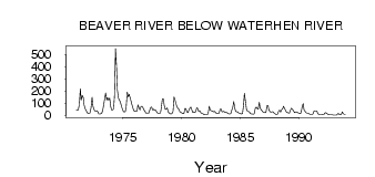
| PointID: | 5577 | Code: | 06AG001 | Latitude (decimal degrees): | 54.81 | Longitude (decimal degrees): | -107.81 | Drainage Area (km2): | 38600.00 | Source: | Hydat | Hydrological Zone: | Northwest Hudson Bay | Name: | BEAVER RIVER BELOW WATERHEN RIVER |
|---|
| Download | |
|---|---|
| Site Descriptor Information | Site Time Series Data |
| Link to all available data | |
| ID | Year | Jan | Feb | Mar | Apr | May | Jun | Jul | Aug | Sep | Oct | Nov | Dec |
|---|---|---|---|---|---|---|---|---|---|---|---|---|---|
| 5577 | 1971 | 44.00 | 40.00 | 43.00 | 88.00 | 219.00 | 124.00 | 163.00 | 147.00 | 83.80 | 53.70 | 39.00 | 22.00 |
| 5577 | 1972 | 17.00 | 15.00 | 20.00 | 60.00 | 149.00 | 77.40 | 46.70 | 33.80 | 35.00 | 36.40 | 27.00 | 11.00 |
| 5577 | 1973 | 11.00 | 13.00 | 15.00 | 40.00 | 92.20 | 133.00 | 183.00 | 124.00 | 145.00 | 125.00 | 141.00 | 72.00 |
| 5577 | 1974 | 44.00 | 44.00 | 55.00 | 152.00 | 549.00 | 387.00 | 207.00 | 139.00 | 123.00 | 112.00 | 75.00 | 50.00 |
| 5577 | 1975 | 34.00 | 25.00 | 32.00 | 67.00 | 190.00 | 152.00 | 173.00 | 143.00 | 110.00 | 84.20 | 54.00 | 35.00 |
| 5577 | 1976 | 33.00 | 36.00 | 35.00 | 84.00 | 62.70 | 43.20 | 70.50 | 72.80 | 63.90 | 48.10 | 34.00 | 18.00 |
| 5577 | 1977 | 18.00 | 19.00 | 17.00 | 38.00 | 61.90 | 66.90 | 42.60 | 48.90 | 41.20 | 42.40 | 31.00 | 16.00 |
| 5577 | 1978 | 14.00 | 16.00 | 20.00 | 64.00 | 135.00 | 133.00 | 79.40 | 48.30 | 52.30 | 61.10 | 27.00 | 16.00 |
| 5577 | 1979 | 12.00 | 10.00 | 16.00 | 30.00 | 150.00 | 123.00 | 96.70 | 67.20 | 57.40 | 45.40 | 29.00 | 23.00 |
| 5577 | 1980 | 18.00 | 13.00 | 15.00 | 57.00 | 53.50 | 28.60 | 20.90 | 39.80 | 59.30 | 66.50 | 48.00 | 24.00 |
| 5577 | 1981 | 27.00 | 24.00 | 28.00 | 61.00 | 59.10 | 33.30 | 38.80 | 26.80 | 15.60 | 13.90 | 8.00 | 5.00 |
| 5577 | 1982 | 4.00 | 3.00 | 3.00 | 28.00 | 74.20 | 42.10 | 35.90 | 36.10 | 28.80 | 32.00 | 25.00 | 18.00 |
| 5577 | 1983 | 13.00 | 12.00 | 17.00 | 49.00 | 51.90 | 27.70 | 30.00 | 32.60 | 22.90 | 25.50 | 21.00 | 17.00 |
| 5577 | 1984 | 11.00 | 11.00 | 14.00 | 46.00 | 61.10 | 114.00 | 61.30 | 32.00 | 28.60 | 27.50 | 20.00 | 17.00 |
| 5577 | 1985 | 12.00 | 10.00 | 15.00 | 84.00 | 180.00 | 116.00 | 47.00 | 35.00 | 30.80 | 27.10 | 15.00 | 10.00 |
| 5577 | 1986 | 11.00 | 9.00 | 12.00 | 59.00 | 68.10 | 55.80 | 50.60 | 106.00 | 61.00 | 45.30 | 35.00 | 25.00 |
| 5577 | 1987 | 23.00 | 22.00 | 23.00 | 79.00 | 80.80 | 44.10 | 29.40 | 25.80 | 27.60 | 27.10 | 19.00 | 14.00 |
| 5577 | 1988 | 6.00 | 7.00 | 11.00 | 36.00 | 41.50 | 26.30 | 46.10 | 55.40 | 74.40 | 55.30 | 38.00 | 25.00 |
| 5577 | 1989 | 22.00 | 19.00 | 17.00 | 43.00 | 58.00 | 47.90 | 38.30 | 22.40 | 25.60 | 28.50 | 24.00 | 19.00 |
| 5577 | 1990 | 17.00 | 13.00 | 22.00 | 72.00 | 95.30 | 42.60 | 31.80 | 20.70 | 16.50 | 16.20 | 12.00 | 7.00 |
| 5577 | 1991 | 6.00 | 7.00 | 8.00 | 32.00 | 37.40 | 36.10 | 37.40 | 13.60 | 8.62 | 7.02 | 6.00 | 5.00 |
| 5577 | 1992 | 4.00 | 4.00 | 15.00 | 22.00 | 16.10 | 11.10 | 5.96 | 3.76 | 3.58 | 3.77 | 3.00 | 2.00 |
| 5577 | 1993 | 1.00 | 1.00 | 2.00 | 9.00 | 13.80 | 6.49 | 4.72 | 9.01 | 27.00 | 14.90 | 7.00 | 5.00 |
 Return to R-Arctic Net Home Page