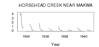
| PointID: | 5566 | Code: | 06AD004 | Latitude (decimal degrees): | 54.03 | Longitude (decimal degrees): | -108.82 | Drainage Area (km2): | 550.00 | Source: | Hydat | Hydrological Zone: | Northwest Hudson Bay | Name: | HORSEHEAD CREEK NEAR MAKWA |
|---|
| Download | |
|---|---|
| Site Descriptor Information | Site Time Series Data |
| Link to all available data | |
| ID | Year | Jan | Feb | Mar | Apr | May | Jun | Jul | Aug | Sep | Oct | Nov | Dec |
|---|---|---|---|---|---|---|---|---|---|---|---|---|---|
| 5566 | 1933 | 3.66 | 4.24 | 1.26 | 0.60 | 0.77 | |||||||
| 5566 | 1934 | 1.52 | 1.07 | 0.86 | 0.10 | 0.07 | 0.09 | ||||||
| 5566 | 1935 | 1.78 | 0.38 | 0.14 | 0.09 | 0.04 | 0.10 | ||||||
| 5566 | 1936 | 0.57 | 0.27 | 0.09 | 0.08 | 0.11 | 0.13 | ||||||
| 5566 | 1937 | 1.03 | 0.27 | 0.17 | 0.08 | 0.01 | 0.08 | ||||||
| 5566 | 1938 | 0.33 | 0.11 | 0.04 | 0.02 | 0.01 | 0.02 | ||||||
| 5566 | 1939 | 0.71 | 0.33 | 0.25 | 0.01 | 0.00 | 0.01 | ||||||
| 5566 | 1940 | 0.21 | 0.13 | 0.07 | 0.01 | 0.00 | 0.00 |
 Return to R-Arctic Net Home Page