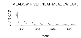
| PointID: | 5565 | Code: | 06AD003 | Latitude (decimal degrees): | 54.22 | Longitude (decimal degrees): | -108.37 | Drainage Area (km2): | 3180.00 | Source: | Hydat | Hydrological Zone: | Northwest Hudson Bay | Name: | MEADOW RIVER NEAR MEADOW LAKE |
|---|
| Download | |
|---|---|
| Site Descriptor Information | Site Time Series Data |
| Link to all available data | |
| ID | Year | Jan | Feb | Mar | Apr | May | Jun | Jul | Aug | Sep | Oct | Nov | Dec |
|---|---|---|---|---|---|---|---|---|---|---|---|---|---|
| 5565 | 1933 | 30.90 | 51.10 | 18.70 | 7.45 | 6.48 | |||||||
| 5565 | 1934 | 13.10 | 8.13 | 9.40 | 3.70 | 4.36 | |||||||
| 5565 | 1935 | 12.50 | 3.76 | 2.79 | 1.81 | 0.54 | 0.50 | ||||||
| 5565 | 1936 | 7.07 | 2.45 | 1.41 | 0.26 | 0.14 | 0.36 | ||||||
| 5565 | 1937 | 9.61 | 4.21 | 1.39 | 0.32 | 0.04 | 2.0e-03 | ||||||
| 5565 | 1938 | 1.18 | 0.79 | 0.42 | 0.05 | 5.0e-03 | 1.0e-03 | ||||||
| 5565 | 1939 | 1.11 | 1.06 | 1.31 | 0.24 | 0.05 | 0.04 | ||||||
| 5565 | 1940 | 0.38 | 0.21 | 0.10 | 0.04 | 1.0e-03 | 0.00 |
 Return to R-Arctic Net Home Page