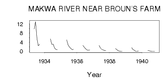
| PointID: | 5564 | Code: | 06AD002 | Latitude (decimal degrees): | 54.20 | Longitude (decimal degrees): | -108.78 | Drainage Area (km2): | 2720.00 | Source: | Hydat | Hydrological Zone: | Northwest Hudson Bay | Name: | MAKWA RIVER NEAR BROUN'S FARM |
|---|
| Download | |
|---|---|
| Site Descriptor Information | Site Time Series Data |
| Link to all available data | |
| ID | Year | Jan | Feb | Mar | Apr | May | Jun | Jul | Aug | Sep | Oct | Nov | Dec |
|---|---|---|---|---|---|---|---|---|---|---|---|---|---|
| 5564 | 1933 | 9.80 | 13.00 | 5.63 | 2.49 | 3.09 | |||||||
| 5564 | 1934 | 5.49 | 3.08 | 3.18 | 1.55 | 0.90 | 0.74 | ||||||
| 5564 | 1935 | 5.05 | 2.81 | 1.94 | 1.35 | 0.81 | 0.90 | ||||||
| 5564 | 1936 | 2.60 | 1.81 | 1.18 | 0.64 | 0.58 | 0.68 | ||||||
| 5564 | 1937 | 2.56 | 1.41 | 0.89 | 0.67 | 0.40 | 0.37 | ||||||
| 5564 | 1938 | 1.21 | 0.80 | 0.35 | 0.10 | 0.04 | 0.06 | ||||||
| 5564 | 1939 | 1.65 | 0.83 | 0.54 | 0.06 | 0.04 | 0.13 | ||||||
| 5564 | 1940 | 0.42 | 0.30 | 0.11 | 0.05 | 0.02 | 0.06 |
 Return to R-Arctic Net Home Page