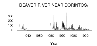
| PointID: | 5563 | Code: | 06AD001 | Latitude (decimal degrees): | 54.29 | Longitude (decimal degrees): | -108.60 | Drainage Area (km2): | 16900.00 | Source: | Hydat | Hydrological Zone: | Northwest Hudson Bay | Name: | BEAVER RIVER NEAR DORINTOSH |
|---|
| Download | |
|---|---|
| Site Descriptor Information | Site Time Series Data |
| Link to all available data | |
| ID | Year | Jan | Feb | Mar | Apr | May | Jun | Jul | Aug | Sep | Oct | Nov | Dec |
|---|---|---|---|---|---|---|---|---|---|---|---|---|---|
| 5563 | 1933 | 115.00 | 62.10 | 48.20 | 36.40 | 20.40 | |||||||
| 5563 | 1934 | 57.80 | 38.40 | 59.50 | 30.70 | 14.30 | 14.60 | ||||||
| 5563 | 1935 | 111.00 | 53.20 | 38.00 | 83.50 | 37.60 | 27.00 | ||||||
| 5563 | 1936 | 127.00 | 50.20 | 26.50 | 13.20 | 13.00 | 16.10 | ||||||
| 5563 | 1937 | 27.70 | 13.20 | 9.30 | 8.56 | 8.85 | 6.86 | ||||||
| 5563 | 1938 | 25.40 | 9.01 | 3.94 | 2.95 | 2.61 | 2.18 | ||||||
| 5563 | 1939 | 32.90 | 19.10 | 18.20 | 7.76 | 3.37 | 3.39 | ||||||
| 5563 | 1940 | 15.70 | 13.50 | 10.20 | 6.81 | 4.52 | 2.64 | ||||||
| 5563 | 1960 | 140.00 | 98.10 | 119.00 | 118.00 | ||||||||
| 5563 | 1961 | 87.00 | 102.00 | 47.80 | 37.00 | 51.80 | 24.30 | ||||||
| 5563 | 1962 | 61.00 | 87.70 | 325.00 | 179.00 | 127.00 | 66.70 | 44.20 | 31.00 | ||||
| 5563 | 1963 | 6.00 | 114.00 | 164.00 | 64.20 | 28.40 | 15.30 | 10.30 | 6.55 | ||||
| 5563 | 1964 | 2.00 | 16.00 | 37.30 | 17.00 | 8.17 | 14.40 | 21.20 | 24.70 | ||||
| 5563 | 1965 | 4.00 | 42.00 | 107.00 | 172.00 | 100.00 | 29.90 | 36.80 | 26.80 | ||||
| 5563 | 1966 | 3.00 | 57.00 | 43.50 | 55.30 | 22.70 | 18.90 | 25.60 | 13.50 | ||||
| 5563 | 1967 | 4.00 | 7.00 | 69.20 | 28.00 | 13.00 | 11.60 | 6.25 | 4.38 | ||||
| 5563 | 1968 | 2.00 | 15.00 | 12.20 | 9.42 | 5.34 | 6.67 | 9.26 | 23.50 | ||||
| 5563 | 1969 | 3.00 | 87.00 | 81.60 | 35.90 | 16.00 | 16.60 | 15.60 | 24.10 | ||||
| 5563 | 1970 | 5.00 | 75.00 | 64.00 | 31.00 | 181.00 | 100.00 | 65.90 | 57.50 | ||||
| 5563 | 1971 | 11.00 | 98.00 | 159.00 | 63.60 | 155.00 | 60.50 | 26.70 | 16.00 | 11.00 | 6.00 | ||
| 5563 | 1972 | 6.00 | 5.00 | 7.00 | 62.00 | 109.00 | 30.70 | 13.80 | 9.36 | 7.35 | 9.08 | 6.00 | 3.00 |
| 5563 | 1973 | 3.00 | 4.00 | 3.00 | 28.00 | 35.30 | 58.90 | 54.80 | 54.70 | 62.50 | 51.80 | 49.00 | 22.00 |
| 5563 | 1974 | 13.00 | 11.00 | 10.00 | 137.00 | 372.00 | 152.00 | 59.50 | 36.80 | 29.20 | 24.30 | 15.00 | 14.00 |
| 5563 | 1975 | 8.00 | 7.00 | 8.00 | 43.00 | 129.00 | 82.50 | 110.00 | 47.80 | 40.90 | 26.30 | 11.00 | 12.00 |
| 5563 | 1976 | 10.00 | 9.00 | 7.00 | 47.00 | 24.50 | 17.90 | 68.50 | 42.80 | 30.50 | 16.40 | 8.00 | 4.00 |
| 5563 | 1977 | 4.00 | 4.00 | 4.00 | 28.00 | 39.30 | 33.40 | 16.30 | 20.80 | 14.90 | 18.10 | 9.00 | 6.00 |
| 5563 | 1978 | 5.00 | 5.00 | 7.00 | 32.00 | 62.70 | 97.10 | 23.40 | 13.10 | 26.80 | 32.20 | 12.00 | 6.00 |
| 5563 | 1979 | 4.00 | 4.00 | 5.00 | 43.00 | 120.00 | 85.60 | 52.30 | 28.00 | 21.70 | 17.80 | 9.00 | 6.00 |
| 5563 | 1980 | 5.00 | 2.00 | 3.00 | 44.00 | 20.00 | 10.40 | 6.75 | 29.20 | 34.50 | 34.20 | 16.00 | 7.00 |
| 5563 | 1981 | 5.00 | 5.00 | 10.00 | 46.00 | 23.80 | 10.30 | 25.60 | 11.50 | 4.78 | 3.73 | 3.00 | 2.00 |
| 5563 | 1982 | 2.00 | 1.00 | 1.00 | 24.00 | 37.20 | 18.10 | 13.40 | 12.00 | 5.89 | 5.34 | 2.00 | 2.00 |
| 5563 | 1983 | 2.00 | 2.00 | 2.00 | 17.00 | 13.10 | 9.37 | 20.50 | 17.00 | 6.92 | 8.30 | 5.00 | 3.00 |
| 5563 | 1984 | 1.00 | 2.00 | 2.00 | 27.00 | 27.30 | 67.70 | 21.00 | 10.10 | 7.76 | 8.01 | 7.00 | 4.00 |
| 5563 | 1985 | 3.00 | 2.00 | 3.00 | 59.00 | 109.00 | 33.40 | 15.00 | 6.27 | 4.61 | 4.89 | 1.00 | 1.00 |
| 5563 | 1986 | 2.00 | 2.00 | 3.00 | 30.00 | 28.40 | 23.70 | 40.50 | 61.50 | 13.30 | 7.83 | 5.00 | 4.00 |
| 5563 | 1987 | 4.00 | 4.00 | 4.00 | 62.00 | 40.40 | 22.90 | 11.30 | 7.90 | 7.58 | 5.22 | 3.00 | 2.00 |
| 5563 | 1988 | 1.00 | 1.00 | 1.00 | 19.00 | 13.20 | 11.20 | 35.70 | 28.00 | 27.10 | 10.00 | 5.00 | 3.00 |
| 5563 | 1989 | 2.00 | 2.00 | 2.00 | 19.00 | 19.60 | 26.00 | 16.70 | 7.47 | 8.64 | 9.75 | 5.00 | 4.00 |
| 5563 | 1990 | 3.00 | 3.00 | 4.00 | 45.00 | 45.50 | 18.10 | 16.00 | 5.75 | 3.48 | 3.23 | 2.00 | 1.00 |
| 5563 | 1991 | 1.00 | 1.00 | 1.00 | 14.00 | 10.60 | 12.70 | 15.70 | 4.10 | 2.38 | 1.59 | 1.00 | 1.00 |
| 5563 | 1992 | 1.00 | 1.00 | 5.00 | 6.00 | 5.32 | 5.43 | 2.78 | 1.84 | 2.11 | 1.87 | 1.00 | 1.00 |
| 5563 | 1993 | 0.00 | 0.00 | 2.00 | 7.00 | 9.02 | 4.65 | 3.42 | 8.74 | 28.90 | 11.40 | 6.00 | 4.00 |
 Return to R-Arctic Net Home Page