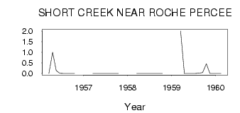
| PointID: | 5525 | Code: | 05NB008 | Latitude (decimal degrees): | 49.06 | Longitude (decimal degrees): | -102.81 | Drainage Area (km2): | 339.00 | Source: | Hydat | Hydrological Zone: | Nelson | Name: | SHORT CREEK NEAR ROCHE PERCEE |
|---|
| Download | |
|---|---|
| Site Descriptor Information | Site Time Series Data |
| Link to all available data | |
| ID | Year | Jan | Feb | Mar | Apr | May | Jun | Jul | Aug | Sep | Oct | Nov | Dec |
|---|---|---|---|---|---|---|---|---|---|---|---|---|---|
| 5525 | 1956 | 0.00 | 1.00 | 0.14 | 7.0e-03 | 2.0e-03 | 0.00 | 0.00 | 0.00 | ||||
| 5525 | 1957 | 0.00 | 0.00 | 6.0e-03 | 0.00 | 0.00 | 0.00 | 0.00 | 0.00 | ||||
| 5525 | 1958 | 0.00 | 0.00 | 0.00 | 0.00 | 0.00 | 0.00 | 0.00 | 0.00 | ||||
| 5525 | 1959 | 2.00 | 0.00 | 4.0e-03 | 2.0e-03 | 0.00 | 0.02 | 0.04 | 0.46 | 0.00 | 0.00 | ||
| 5525 | 1960 | 0.00 | 0.00 |
 Return to R-Arctic Net Home Page