| PointID: | 55 | Code: | 05AC001 | Latitude (decimal degrees): | 50.37 | Longitude (decimal degrees): | -113.82 | Drainage Area (km2): | 522.00 | Source: | Hydat | Hydrological Zone: | Nelson | Name: | MOSQUITO CREEK NEAR NANTON |
|---|
| Download | |
|---|---|
| Site Descriptor Information | Site Time Series Data |
| Link to all available data | |
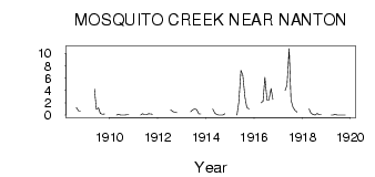
| ID | Year | Jan | Feb | Mar | Apr | May | Jun | Jul | Aug | Sep | Oct | Nov | Dec |
|---|---|---|---|---|---|---|---|---|---|---|---|---|---|
| 55 | 1908 | 1.24 | 0.72 | 0.69 | |||||||||
| 55 | 1909 | 4.24 | 0.97 | 1.17 | 0.26 | 0.16 | 0.19 | ||||||
| 55 | 1910 | 0.00 | 0.15 | 0.03 | 0.00 | 0.00 | 0.05 | 0.04 | |||||
| 55 | 1911 | 0.00 | 0.23 | 0.06 | 0.07 | 0.25 | 0.18 | 0.14 | |||||
| 55 | 1912 | 0.87 | 0.58 | 0.49 | 0.40 | ||||||||
| 55 | 1913 | 0.54 | 0.88 | 1.02 | 0.87 | 0.19 | 0.20 | ||||||
| 55 | 1914 | 1.00 | 0.30 | 0.08 | 0.01 | 0.00 | 0.00 | 0.22 | |||||
| 55 | 1915 | 0.00 | 2.08 | 7.27 | 6.46 | 2.96 | 1.28 | 1.01 | |||||
| 55 | 1916 | 2.00 | 2.24 | 6.13 | 2.44 | 2.44 | 4.31 | 2.54 | |||||
| 55 | 1917 | 4.00 | 4.86 | 10.80 | 2.43 | 1.23 | 0.78 | 0.50 | |||||
| 55 | 1918 | 1.00 | 0.33 | 0.08 | 0.01 | 0.27 | 0.04 | 0.04 | |||||
| 55 | 1919 | 0.00 | 0.00 | 0.13 | 0.01 | 0.00 | 0.00 | 2.0e-03 | 8.0e-03 |
 Return to R-Arctic Net Home Page