| PointID: | 5497 | Code: | 05MA025 | Latitude (decimal degrees): | 52.40 | Longitude (decimal degrees): | -104.78 | Drainage Area (km2): | 87.00 | Source: | Hydat | Hydrological Zone: | Nelson | Name: | RANCH CREEK ABOVE RANCH LAKE |
|---|
| Download | |
|---|---|
| Site Descriptor Information | Site Time Series Data |
| Link to all available data | |
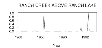
| ID | Year | Jan | Feb | Mar | Apr | May | Jun | Jul | Aug | Sep | Oct | Nov | Dec |
|---|---|---|---|---|---|---|---|---|---|---|---|---|---|
| 5497 | 1986 | 0.00 | 0.00 | 3.0e-03 | 0.00 | 0.00 | 0.00 | 0.00 | 0.00 | ||||
| 5497 | 1987 | 0.00 | 0.00 | 0.01 | 0.03 | 0.00 | 0.00 | 0.00 | 0.00 | ||||
| 5497 | 1988 | 0.00 | 1.00 | 0.01 | 0.00 | 0.00 | 0.00 | 0.00 | 0.00 | ||||
| 5497 | 1989 | 0.00 | 0.00 | 0.00 | 0.00 | 0.00 | 0.00 | 0.00 | 0.00 | ||||
| 5497 | 1990 | 0.00 | 0.00 | 0.02 | 0.00 | 0.00 | 0.00 | 0.00 | 0.00 | ||||
| 5497 | 1991 | 0.00 | 0.00 | 0.01 | 7.0e-03 | 8.0e-03 | 0.21 | 0.00 | 0.00 | ||||
| 5497 | 1992 | 0.00 | 1.00 | 0.08 | 1.0e-03 | 0.00 | 0.00 | 0.00 | 0.00 |
 Return to R-Arctic Net Home Page