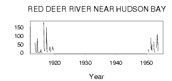
| PointID: | 5478 | Code: | 05LC002 | Latitude (decimal degrees): | 52.81 | Longitude (decimal degrees): | -102.36 | Drainage Area (km2): | 8410.00 | Source: | Hydat | Hydrological Zone: | Nelson | Name: | RED DEER RIVER NEAR HUDSON BAY |
|---|
| Download | |
|---|---|
| Site Descriptor Information | Site Time Series Data |
| Link to all available data | |
| ID | Year | Jan | Feb | Mar | Apr | May | Jun | Jul | Aug | Sep | Oct | Nov | Dec |
|---|---|---|---|---|---|---|---|---|---|---|---|---|---|
| 5478 | 1913 | 56.40 | 27.30 | 14.60 | 9.00 | 3.00 | |||||||
| 5478 | 1914 | 1.00 | 1.00 | 0.00 | 51.00 | 85.20 | 29.80 | 7.59 | 2.20 | 2.25 | 2.35 | 1.00 | 0.00 |
| 5478 | 1915 | 0.00 | 0.00 | 0.00 | 7.00 | 3.76 | 4.30 | 20.10 | 4.55 | 2.29 | 2.25 | 1.00 | 0.00 |
| 5478 | 1916 | 170.00 | 181.00 | 58.00 | 26.40 | 10.50 | 15.30 | 12.00 | |||||
| 5478 | 1917 | 19.00 | 150.00 | 60.00 | 47.20 | 7.39 | 4.69 | 2.82 | |||||
| 5478 | 1918 | 18.00 | 13.20 | 33.90 | 34.20 | 20.90 | 5.56 | 6.69 | |||||
| 5478 | 1919 | 17.00 | 36.70 | 24.70 | 24.40 | 14.90 | 13.70 | ||||||
| 5478 | 1950 | 20.30 | 4.27 | 4.93 | |||||||||
| 5478 | 1951 | 88.50 | 30.40 | 25.70 | 17.10 | 36.70 | 51.20 | 10.00 | |||||
| 5478 | 1952 | 63.60 | 22.50 | 18.40 | 8.96 | 3.17 | 3.00 | 3.00 | |||||
| 5478 | 1953 | 29.00 | 61.50 | 92.10 | 109.00 | 58.30 | 61.80 | 13.50 | 10.00 |
 Return to R-Arctic Net Home Page