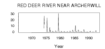
| PointID: | 5465 | Code: | 05LA005 | Latitude (decimal degrees): | 52.43 | Longitude (decimal degrees): | -103.69 | Drainage Area (km2): | 1130.00 | Source: | Hydat | Hydrological Zone: | Nelson | Name: | RED DEER RIVER NEAR ARCHERWILL |
|---|
| Download | |
|---|---|
| Site Descriptor Information | Site Time Series Data |
| Link to all available data | |
| ID | Year | Jan | Feb | Mar | Apr | May | Jun | Jul | Aug | Sep | Oct | Nov | Dec |
|---|---|---|---|---|---|---|---|---|---|---|---|---|---|
| 5465 | 1966 | 11.60 | |||||||||||
| 5465 | 1967 | 3.52 | |||||||||||
| 5465 | 1969 | 2.00 | |||||||||||
| 5465 | 1972 | 27.10 | |||||||||||
| 5465 | 1974 | 6.00 | 26.20 | 12.10 | |||||||||
| 5465 | 1975 | 0.00 | 4.00 | 23.10 | 6.68 | 0.05 | 0.01 | 5.0e-03 | 5.0e-03 | ||||
| 5465 | 1976 | 0.00 | 6.00 | 7.35 | 0.44 | 2.62 | 0.48 | 0.03 | 6.0e-03 | ||||
| 5465 | 1977 | 0.00 | 1.00 | 1.42 | 0.21 | 0.01 | 0.00 | 1.0e-03 | 0.00 | ||||
| 5465 | 1978 | 0.00 | 1.00 | 1.79 | 1.75 | 0.42 | 0.04 | 0.06 | 0.04 | ||||
| 5465 | 1979 | 0.00 | 4.00 | 30.40 | 5.24 | 1.97 | 0.28 | 0.01 | 6.0e-03 | ||||
| 5465 | 1980 | 0.00 | 0.00 | 1.23 | 0.01 | 9.0e-03 | 0.02 | 3.0e-03 | 0.11 | ||||
| 5465 | 1981 | 0.00 | 0.00 | 1.02 | 0.27 | 0.13 | 0.02 | 0.01 | 0.04 | ||||
| 5465 | 1982 | 0.00 | 0.00 | 0.37 | 0.48 | 0.64 | 0.32 | 0.21 | 0.11 | ||||
| 5465 | 1983 | 0.00 | 0.00 | 1.55 | 1.41 | 1.17 | 0.35 | 0.24 | 0.00 | ||||
| 5465 | 1984 | 0.00 | 1.00 | 3.14 | 2.20 | 1.45 | 0.16 | 8.0e-03 | 0.04 | ||||
| 5465 | 1985 | 0.00 | 9.00 | 10.50 | 1.71 | 0.30 | 1.03 | 0.03 | 0.25 | ||||
| 5465 | 1986 | 0.00 | 3.00 | 3.18 | 2.82 | 0.28 | 7.0e-03 | 5.0e-03 | 0.01 | ||||
| 5465 | 1987 | 0.00 | 1.00 | 0.28 | 0.07 | 0.09 | 0.00 | 0.02 | 0.00 | ||||
| 5465 | 1988 | 0.00 | 4.00 | 2.84 | 0.89 | 0.35 | 0.20 | 0.00 | 0.00 | ||||
| 5465 | 1989 | 0.00 | 0.00 | 0.11 | 4.0e-03 | 0.00 | 0.00 | 0.00 | 0.00 | ||||
| 5465 | 1990 | 0.00 | 0.00 | 0.28 | 0.10 | 1.52 | 0.00 | 0.00 | 4.0e-03 | ||||
| 5465 | 1991 | 0.00 | 0.00 | 5.0e-03 | 0.09 | 5.0e-03 | 0.00 | 0.00 | 0.00 | ||||
| 5465 | 1992 | 0.00 | 0.00 | 0.96 | 1.13 | 2.42 | 0.34 | 0.00 | 0.00 |
 Return to R-Arctic Net Home Page