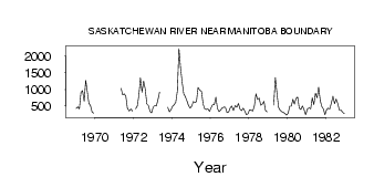
| PointID: | 5454 | Code: | 05KH008 | Latitude (decimal degrees): | 53.88 | Longitude (decimal degrees): | -101.82 | Drainage Area (km2): | 328000.00 | Source: | Hydat | Hydrological Zone: | Nelson | Name: | SASKATCHEWAN RIVER NEAR MANITOBA BOUNDARY |
|---|
| Download | |
|---|---|
| Site Descriptor Information | Site Time Series Data |
| Link to all available data | |
| ID | Year | Jan | Feb | Mar | Apr | May | Jun | Jul | Aug | Sep | Oct | Nov | Dec |
|---|---|---|---|---|---|---|---|---|---|---|---|---|---|
| 5454 | 1969 | 432.00 | 476.00 | 415.00 | 911.00 | 966.00 | 648.00 | 1280.00 | 928.00 | 583.00 | 513.00 | 314.00 | 287.00 |
| 5454 | 1970 | 686.00 | 378.00 | ||||||||||
| 5454 | 1971 | 558.00 | 1040.00 | 840.00 | 867.00 | 796.00 | 432.00 | 348.00 | 417.00 | 349.00 | |||
| 5454 | 1972 | 423.00 | 491.00 | 822.00 | 1350.00 | 915.00 | 1250.00 | 1010.00 | 562.00 | 520.00 | 341.00 | 290.00 | |
| 5454 | 1973 | 473.00 | 520.00 | 503.00 | 691.00 | 913.00 | 461.00 | 328.00 | 387.00 | ||||
| 5454 | 1974 | 493.00 | 545.00 | 614.00 | 946.00 | 2230.00 | 1650.00 | 1220.00 | 868.00 | 783.00 | 665.00 | 517.00 | 434.00 |
| 5454 | 1975 | 494.00 | 634.00 | 604.00 | 637.00 | 1060.00 | 983.00 | 940.00 | 555.00 | 416.00 | 401.00 | 411.00 | 341.00 |
| 5454 | 1976 | 442.00 | 544.00 | 543.00 | 768.00 | 431.00 | 333.00 | 383.00 | 447.00 | 466.00 | 460.00 | 298.00 | 316.00 |
| 5454 | 1977 | 447.00 | 498.00 | 362.00 | 519.00 | 459.00 | 579.00 | 409.00 | 362.00 | 436.00 | 352.00 | 238.00 | 270.00 |
| 5454 | 1978 | 389.00 | 374.00 | 353.00 | 499.00 | 872.00 | 699.00 | 740.00 | 526.00 | 559.00 | 642.00 | 368.00 | 323.00 |
| 5454 | 1979 | 531.00 | 1360.00 | 891.00 | 461.00 | 377.00 | 337.00 | 307.00 | 274.00 | 227.00 | |||
| 5454 | 1980 | 281.00 | 492.00 | 492.00 | 698.00 | 558.00 | 723.00 | 771.00 | 438.00 | 394.00 | 502.00 | 401.00 | 234.00 |
| 5454 | 1981 | 413.00 | 448.00 | 416.00 | 752.00 | 545.00 | 886.00 | 750.00 | 1070.00 | 673.00 | 486.00 | 412.00 | 238.00 |
| 5454 | 1982 | 388.00 | 439.00 | 411.00 | 596.00 | 793.00 | 573.00 | 708.00 | 571.00 | 379.00 | 379.00 | 311.00 | 271.00 |
| Other Close Sites | ||||||
|---|---|---|---|---|---|---|
| PointID | Latitude | Longitude | Drainage Area | Source | Name | |
| 5456 | 53.88 | -101.93 | 206000.00 | Hydat | SASKATCHEWAN RIVER BELOW CUMBERLAND HOUSE | |
 Return to R-Arctic Net Home Page