| PointID: | 5439 | Code: | 05KD001 | Latitude (decimal degrees): | 53.36 | Longitude (decimal degrees): | -104.03 | Drainage Area (km2): | 166000.00 | Source: | Hydat | Hydrological Zone: | Nelson | Name: | SASKATCHEWAN RIVER AT NIPAWIN |
|---|
| Download | |
|---|---|
| Site Descriptor Information | Site Time Series Data |
| Link to all available data | |
| ID | Year | Jan | Feb | Mar | Apr | May | Jun | Jul | Aug | Sep | Oct | Nov | Dec |
|---|---|---|---|---|---|---|---|---|---|---|---|---|---|
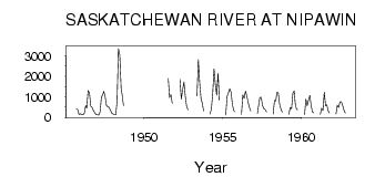
| 5439 | 1945 | 407.00 | 378.00 | 143.00 | 173.00 | ||||||||
| 5439 | 1946 | 140.00 | 130.00 | 205.00 | 573.00 | 450.00 | 1300.00 | 1200.00 | 536.00 | 484.00 | 338.00 | 228.00 | 131.00 |
| 5439 | 1947 | 129.00 | 107.00 | 249.00 | 981.00 | 1110.00 | 1260.00 | 1020.00 | 572.00 | 511.00 | 486.00 | 343.00 | 202.00 |
| 5439 | 1948 | 160.00 | 122.00 | 126.00 | 839.00 | 3360.00 | 3040.00 | 1440.00 | 1080.00 | 566.00 | |||
| 5439 | 1951 | 1900.00 | 966.00 | 1110.00 | 677.00 | ||||||||
| 5439 | 1952 | 1850.00 | 892.00 | 1350.00 | 1730.00 | 1030.00 | 543.00 | 367.00 | |||||
| 5439 | 1953 | 1050.00 | 2820.00 | 1690.00 | 927.00 | 667.00 | 302.00 | ||||||
| 5439 | 1954 | 162.00 | 406.00 | 1160.00 | 2370.00 | 1610.00 | 1090.00 | 2160.00 | 824.00 | ||||
| 5439 | 1955 | 115.00 | 1020.00 | 1200.00 | 1400.00 | 1230.00 | 620.00 | 338.00 | 263.00 | ||||
| 5439 | 1956 | 131.00 | 1100.00 | 926.00 | 1280.00 | 1040.00 | 729.00 | 471.00 | 300.00 | ||||
| 5439 | 1957 | 187.00 | 643.00 | 969.00 | 979.00 | 575.00 | 420.00 | 388.00 | 269.00 | ||||
| 5439 | 1958 | 149.00 | 828.00 | 801.00 | 1210.00 | 1220.00 | 656.00 | 414.00 | 260.00 | ||||
| 5439 | 1959 | 144.00 | 476.00 | 416.00 | 1180.00 | 1290.00 | 662.00 | 390.00 | 379.00 | ||||
| 5439 | 1960 | 141.00 | 885.00 | 567.00 | 847.00 | 1070.00 | 630.00 | 286.00 | 216.00 | ||||
| 5439 | 1961 | 133.00 | 451.00 | 329.00 | 1230.00 | 562.00 | 600.00 | 341.00 | 213.00 | ||||
| 5439 | 1962 | 157.00 | 586.00 | 469.00 | 755.00 | 764.00 | 578.00 | 345.00 | 206.00 |
 Return to R-Arctic Net Home Page