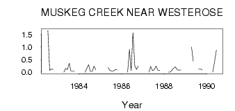
| PointID: | 541 | Code: | 05FA912 | Latitude (decimal degrees): | 52.86 | Longitude (decimal degrees): | -113.95 | Drainage Area (km2): | 87.69 | Source: | Hydat | Hydrological Zone: | Nelson | Name: | MUSKEG CREEK NEAR WESTEROSE |
|---|
| Download | |
|---|---|
| Site Descriptor Information | Site Time Series Data |
| Link to all available data | |
| ID | Year | Jan | Feb | Mar | Apr | May | Jun | Jul | Aug | Sep | Oct | Nov | Dec |
|---|---|---|---|---|---|---|---|---|---|---|---|---|---|
| 541 | 1982 | 1.66 | 0.07 | 0.12 | 0.11 | ||||||||
| 541 | 1983 | 0.00 | 0.15 | 0.11 | 0.35 | 0.05 | 0.05 | 0.05 | |||||
| 541 | 1984 | 0.00 | 0.16 | 0.30 | 0.03 | 0.03 | 0.24 | 0.10 | |||||
| 541 | 1985 | 0.19 | 0.07 | 0.05 | 0.05 | 0.11 | 0.09 | ||||||
| 541 | 1986 | 0.00 | 0.90 | 0.06 | 1.57 | 0.26 | 0.11 | 0.25 | |||||
| 541 | 1987 | 0.00 | 0.23 | 0.06 | 0.10 | 0.25 | 0.08 | 0.06 | |||||
| 541 | 1988 | 0.00 | 0.00 | 0.08 | 0.16 | 0.21 | 0.09 | 0.08 | 0.09 | ||||
| 541 | 1989 | 1.00 | 0.44 | 0.13 | 0.13 | 0.09 | |||||||
| 541 | 1990 | 0.00 | 0.42 | 0.88 |
 Return to R-Arctic Net Home Page