| PointID: | 5335 | Code: | 05HG021 | Latitude (decimal degrees): | 51.50 | Longitude (decimal degrees): | -106.82 | Drainage Area (km2): | 38.59 | Source: | Hydat | Hydrological Zone: | Nelson | Name: | INVERNESS CREEK NEAR BRODERICK |
|---|
| Download | |
|---|---|
| Site Descriptor Information | Site Time Series Data |
| Link to all available data | |
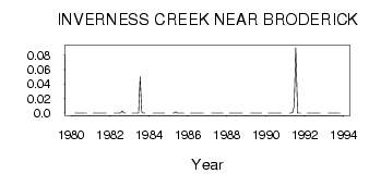
| ID | Year | Jan | Feb | Mar | Apr | May | Jun | Jul | Aug | Sep | Oct | Nov | Dec |
|---|---|---|---|---|---|---|---|---|---|---|---|---|---|
| 5335 | 1980 | 0.00 | 0.00 | 0.00 | 0.00 | 0.00 | 0.00 | 0.00 | 0.00 | ||||
| 5335 | 1981 | 0.00 | 0.00 | 0.00 | 0.00 | 0.00 | 0.00 | 0.00 | 0.00 | 0.00 | |||
| 5335 | 1982 | 0.00 | 0.00 | 0.00 | 0.00 | 0.00 | 3.0e-03 | 0.00 | 0.00 | ||||
| 5335 | 1983 | 0.00 | 0.00 | 0.00 | 0.00 | 0.00 | 0.05 | 2.0e-03 | 0.00 | 0.00 | |||
| 5335 | 1984 | 0.00 | 0.00 | 0.00 | 0.00 | 0.00 | 0.00 | 0.00 | 0.00 | ||||
| 5335 | 1985 | 0.00 | 0.00 | 2.0e-03 | 0.00 | 0.00 | 0.00 | 0.00 | 0.00 | ||||
| 5335 | 1986 | 0.00 | 0.00 | 0.00 | 0.00 | 0.00 | 0.00 | 0.00 | 0.00 | 0.00 | |||
| 5335 | 1987 | 0.00 | 0.00 | 0.00 | 0.00 | 0.00 | 0.00 | 0.00 | 0.00 | ||||
| 5335 | 1988 | 0.00 | 0.00 | 0.00 | 0.00 | 0.00 | 0.00 | 0.00 | 0.00 | 0.00 | |||
| 5335 | 1989 | 0.00 | 0.00 | 0.00 | 0.00 | 0.00 | 0.00 | 0.00 | 0.00 | ||||
| 5335 | 1990 | 0.00 | 0.00 | 0.00 | 0.00 | 0.00 | 0.00 | 0.00 | 0.00 | 0.00 | |||
| 5335 | 1991 | 0.00 | 0.00 | 1.0e-03 | 0.01 | 0.09 | 0.00 | 0.00 | 0.00 | ||||
| 5335 | 1992 | 0.00 | 0.00 | 0.00 | 0.00 | 0.00 | 0.00 | 0.00 | 0.00 | 0.00 | |||
| 5335 | 1993 | 0.00 | 0.00 | 0.00 | 0.00 | 0.00 | 0.00 | 0.00 | 0.00 |
 Return to R-Arctic Net Home Page