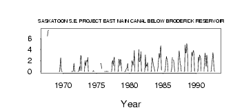
| PointID: | 5333 | Code: | 05HG019 | Latitude (decimal degrees): | 51.48 | Longitude (decimal degrees): | -106.84 | Drainage Area (km2): | Source: | Hydat | Hydrological Zone: | Nelson | Name: | SASKATOON S.E. PROJECT EAST MAIN CANAL BELOW BRODERICK RESERVOIR |
|---|
| Download | |
|---|---|
| Site Descriptor Information | Site Time Series Data |
| Link to all available data | |
| ID | Year | Jan | Feb | Mar | Apr | May | Jun | Jul | Aug | Sep | Oct | Nov | Dec |
|---|---|---|---|---|---|---|---|---|---|---|---|---|---|
| 5333 | 1967 | 6.46 | 7.41 | 7.53 | |||||||||
| 5333 | 1969 | 0.00 | 0.02 | 1.55 | 2.49 | 0.06 | 0.00 | 0.00 | |||||
| 5333 | 1971 | 0.00 | 0.00 | 9.0e-03 | 7.0e-03 | 0.32 | 1.50 | 0.02 | 0.01 | ||||
| 5333 | 1972 | 0.00 | 0.00 | 0.25 | 0.91 | 0.17 | 2.91 | 2.80 | 0.12 | ||||
| 5333 | 1973 | 0.00 | 2.00 | 1.04 | 1.59 | 2.02 | 1.86 | 2.55 | 0.00 | ||||
| 5333 | 1974 | 7.0e-03 | 0.17 | 6.0e-03 | |||||||||
| 5333 | 1975 | 1.47 | 1.45 | 0.53 | |||||||||
| 5333 | 1976 | 0.00 | 0.00 | 1.0e-03 | 5.0e-03 | 0.03 | 0.02 | 0.00 | 8.0e-03 | ||||
| 5333 | 1977 | 0.00 | 0.00 | 1.65 | 2.03 | 1.09 | 2.20 | 2.63 | 6.0e-03 | ||||
| 5333 | 1978 | 0.00 | 0.00 | 2.26 | 1.98 | 1.07 | 2.19 | 2.06 | 0.06 | ||||
| 5333 | 1979 | 0.00 | 0.00 | 0.00 | 0.35 | 0.62 | 0.71 | 1.49 | 0.09 | ||||
| 5333 | 1980 | 0.00 | 0.00 | 2.03 | 1.50 | 1.13 | 2.05 | 3.82 | 7.0e-03 | ||||
| 5333 | 1981 | 0.00 | 0.00 | 4.00 | 1.85 | 1.78 | 2.25 | 3.65 | 0.02 | ||||
| 5333 | 1982 | 0.00 | 0.00 | 3.04 | 0.72 | 1.26 | 1.01 | 1.63 | 0.03 | ||||
| 5333 | 1983 | 0.00 | 0.00 | 2.53 | 2.31 | 1.48 | 0.98 | 0.67 | 7.0e-03 | ||||
| 5333 | 1984 | 0.00 | 1.00 | 2.36 | 3.28 | 2.46 | 4.12 | 4.70 | 0.25 | ||||
| 5333 | 1985 | 0.00 | 0.00 | 0.16 | 1.47 | 2.73 | 2.28 | 1.92 | 1.0e-03 | ||||
| 5333 | 1986 | 0.00 | 0.00 | 0.95 | 2.58 | 2.13 | 1.13 | 3.0e-03 | |||||
| 5333 | 1987 | 0.00 | 0.00 | 2.43 | 3.75 | 2.95 | 1.30 | 1.11 | 6.0e-03 | ||||
| 5333 | 1988 | 0.00 | 0.00 | 4.85 | 3.37 | 3.53 | 5.09 | 4.23 | 0.01 | ||||
| 5333 | 1989 | 0.00 | 0.00 | 3.53 | 2.80 | 3.47 | 3.87 | 2.94 | 5.0e-03 | ||||
| 5333 | 1990 | 0.00 | 0.00 | 2.65 | 1.86 | 3.01 | 2.74 | 2.41 | 0.07 | ||||
| 5333 | 1991 | 0.00 | 2.00 | 3.37 | 1.95 | 0.92 | 3.02 | 2.27 | 1.0e-03 | ||||
| 5333 | 1992 | 0.00 | 0.00 | 1.20 | 2.05 | 3.43 | 2.78 | 0.64 | 2.0e-03 |
 Return to R-Arctic Net Home Page