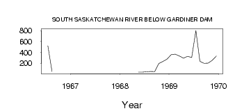
| PointID: | 5308 | Code: | 05HF004 | Latitude (decimal degrees): | 51.32 | Longitude (decimal degrees): | -106.95 | Drainage Area (km2): | 87000.00 | Source: | Hydat | Hydrological Zone: | Nelson | Name: | SOUTH SASKATCHEWAN RIVER BELOW GARDINER DAM |
|---|
| Download | |
|---|---|
| Site Descriptor Information | Site Time Series Data |
| Link to all available data | |
| ID | Year | Jan | Feb | Mar | Apr | May | Jun | Jul | Aug | Sep | Oct | Nov | Dec |
|---|---|---|---|---|---|---|---|---|---|---|---|---|---|
| 5308 | 1966 | 520.00 | 44.70 | ||||||||||
| 5308 | 1968 | 37.10 | 35.10 | 41.80 | 48.50 | 45.30 | 195.00 | 231.00 | 275.00 | ||||
| 5308 | 1969 | 358.00 | 368.00 | 334.00 | 294.00 | 328.00 | 305.00 | 804.00 | 237.00 | 199.00 | 203.00 | 255.00 | 333.00 |
 Return to R-Arctic Net Home Page