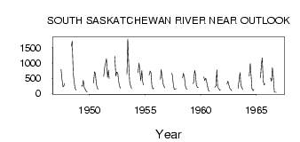
| PointID: | 5307 | Code: | 05HF001 | Latitude (decimal degrees): | 51.47 | Longitude (decimal degrees): | -107.07 | Drainage Area (km2): | 87300.00 | Source: | Hydat | Hydrological Zone: | Nelson | Name: | SOUTH SASKATCHEWAN RIVER NEAR OUTLOOK |
|---|
| Download | |
|---|---|
| Site Descriptor Information | Site Time Series Data |
| Link to all available data | |
| ID | Year | Jan | Feb | Mar | Apr | May | Jun | Jul | Aug | Sep | Oct | Nov | Dec |
|---|---|---|---|---|---|---|---|---|---|---|---|---|---|
| 5307 | 1947 | 782.00 | 471.00 | 210.00 | 250.00 | 331.00 | |||||||
| 5307 | 1948 | 1550.00 | 1710.00 | 649.00 | 403.00 | 178.00 | 104.00 | ||||||
| 5307 | 1949 | 255.00 | 232.00 | 423.00 | 181.00 | 140.00 | 65.40 | 45.60 | |||||
| 5307 | 1950 | 339.00 | 717.00 | 657.00 | 328.00 | 166.00 | 131.00 | ||||||
| 5307 | 1951 | 557.00 | 886.00 | 995.00 | 1140.00 | 523.00 | 763.00 | 483.00 | |||||
| 5307 | 1952 | 1210.00 | 569.00 | 697.00 | 673.00 | 404.00 | 239.00 | 164.00 | |||||
| 5307 | 1953 | 616.00 | 1790.00 | 856.00 | 369.00 | 251.00 | 152.00 | ||||||
| 5307 | 1954 | 676.00 | 998.00 | 720.00 | 416.00 | 750.00 | 374.00 | 277.00 | |||||
| 5307 | 1955 | 597.00 | 736.00 | 682.00 | 255.00 | 146.00 | 164.00 | ||||||
| 5307 | 1956 | 464.00 | 784.00 | 551.00 | 313.00 | 226.00 | 181.00 | ||||||
| 5307 | 1957 | 659.00 | 612.00 | 275.00 | 135.00 | 140.00 | 151.00 | ||||||
| 5307 | 1958 | 505.00 | 657.00 | 527.00 | 257.00 | 155.00 | 142.00 | ||||||
| 5307 | 1959 | 321.00 | 352.00 | 759.00 | 624.00 | 265.00 | 194.00 | 205.00 | |||||
| 5307 | 1960 | 537.00 | 418.00 | 498.00 | 390.00 | 208.00 | 97.40 | 69.70 | |||||
| 5307 | 1961 | 200.00 | 243.00 | 774.00 | 194.00 | 160.00 | 103.00 | 118.00 | |||||
| 5307 | 1962 | 307.00 | 397.00 | 267.00 | 158.00 | 140.00 | 85.80 | ||||||
| 5307 | 1963 | 167.00 | 421.00 | 689.00 | 270.00 | 175.00 | 128.00 | ||||||
| 5307 | 1964 | 566.00 | 984.00 | 578.00 | 153.00 | 86.20 | 125.00 | ||||||
| 5307 | 1965 | 506.00 | 936.00 | 1170.00 | 396.00 | 271.00 | 312.00 | ||||||
| 5307 | 1966 | 504.00 | 391.00 | 837.00 | 575.00 | 52.90 | 32.00 | 31.20 |
 Return to R-Arctic Net Home Page