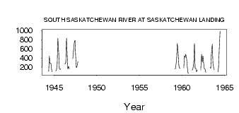
| PointID: | 5281 | Code: | 05HC001 | Latitude (decimal degrees): | 50.65 | Longitude (decimal degrees): | -107.97 | Drainage Area (km2): | 81900.00 | Source: | Hydat | Hydrological Zone: | Nelson | Name: | SOUTH SASKATCHEWAN RIVER AT SASKATCHEWAN LANDING |
|---|
| Download | |
|---|---|
| Site Descriptor Information | Site Time Series Data |
| Link to all available data | |
| ID | Year | Jan | Feb | Mar | Apr | May | Jun | Jul | Aug | Sep | Oct | Nov | Dec |
|---|---|---|---|---|---|---|---|---|---|---|---|---|---|
| 5281 | 1944 | 107.00 | 441.00 | 283.00 | 287.00 | 149.00 | 98.50 | ||||||
| 5281 | 1945 | 118.00 | 141.00 | 268.00 | 830.00 | 526.00 | 165.00 | 152.00 | 161.00 | ||||
| 5281 | 1946 | 266.00 | 303.00 | 832.00 | 480.00 | 158.00 | 218.00 | 164.00 | |||||
| 5281 | 1947 | 381.00 | 577.00 | 742.00 | 788.00 | 437.00 | 189.00 | 234.00 | 322.00 | ||||
| 5281 | 1959 | 159.00 | 250.00 | 386.00 | 718.00 | 567.00 | 239.00 | 175.00 | 186.00 | ||||
| 5281 | 1960 | 181.00 | 452.00 | 411.00 | 479.00 | 379.00 | 193.00 | 71.40 | 60.80 | ||||
| 5281 | 1961 | 131.00 | 173.00 | 288.00 | 722.00 | 171.00 | 172.00 | 97.40 | 139.00 | ||||
| 5281 | 1962 | 135.00 | 481.00 | 308.00 | 445.00 | 291.00 | 164.00 | 152.00 | 85.50 | ||||
| 5281 | 1963 | 193.00 | 174.00 | 504.00 | 701.00 | 277.00 | 187.00 | 140.00 | |||||
| 5281 | 1964 | 97.00 | 195.00 | 583.00 | 989.00 |
 Return to R-Arctic Net Home Page