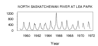
| PointID: | 524 | Code: | 05EF003 | Latitude (decimal degrees): | 53.65 | Longitude (decimal degrees): | -110.33 | Drainage Area (km2): | 47700.00 | Source: | Hydat | Hydrological Zone: | Nelson | Name: | NORTH SASKATCHEWAN RIVER AT LEA PARK |
|---|
| Download | |
|---|---|
| Site Descriptor Information | Site Time Series Data |
| Link to all available data | |
| ID | Year | Jan | Feb | Mar | Apr | May | Jun | Jul | Aug | Sep | Oct | Nov | Dec |
|---|---|---|---|---|---|---|---|---|---|---|---|---|---|
| 524 | 1958 | 117.00 | 67.00 | 28.00 | |||||||||
| 524 | 1959 | 33.00 | 36.00 | 48.00 | 119.00 | 171.00 | 579.00 | 573.00 | 302.00 | 201.00 | 157.00 | 76.00 | 62.00 |
| 524 | 1960 | 48.00 | 38.00 | 61.00 | 152.00 | 209.00 | 344.00 | 583.00 | 330.00 | 164.00 | 103.00 | 59.00 | 35.00 |
| 524 | 1961 | 42.00 | 32.00 | 44.00 | 82.00 | 220.00 | 515.00 | 376.00 | 434.00 | 192.00 | 103.00 | 75.00 | 39.00 |
| 524 | 1962 | 51.00 | 58.00 | 53.00 | 205.00 | 224.00 | 423.00 | 512.00 | 386.00 | 205.00 | 130.00 | 163.00 | 71.00 |
| 524 | 1963 | 65.00 | 84.00 | 84.00 | 404.00 | 358.00 | 480.00 | 529.00 | 355.00 | 230.00 | 122.00 | 60.00 | 97.00 |
| 524 | 1964 | 86.00 | 82.00 | 77.00 | 112.00 | 358.00 | 686.00 | 526.00 | 239.00 | 227.00 | 233.00 | 109.00 | 74.00 |
| 524 | 1965 | 60.00 | 71.00 | 135.00 | 362.00 | 365.00 | 1020.00 | 1260.00 | 500.00 | 315.00 | 262.00 | 127.00 | 93.00 |
| 524 | 1966 | 99.00 | 99.00 | 86.00 | 192.00 | 242.00 | 359.00 | 624.00 | 514.00 | 268.00 | 186.00 | 96.00 | 72.00 |
| 524 | 1967 | 77.00 | 90.00 | 76.00 | 105.00 | 318.00 | 732.00 | 468.00 | 291.00 | 197.00 | 97.60 | 58.00 | 55.00 |
| 524 | 1968 | 76.00 | 86.00 | 101.00 | 151.00 | 163.00 | 341.00 | 401.00 | 385.00 | 219.00 | 142.00 | 74.00 | 67.00 |
| 524 | 1969 | 90.00 | 72.00 | 80.00 | 241.00 | 271.00 | 383.00 | 690.00 | 422.00 | 231.00 | 121.00 | ||
| 524 | 1970 | 219.00 | 518.00 | 467.00 | 264.00 | 138.00 | 88.10 | ||||||
| 524 | 1971 | 254.00 | 623.00 | 540.00 | 420.00 | 161.00 | 110.00 |
 Return to R-Arctic Net Home Page