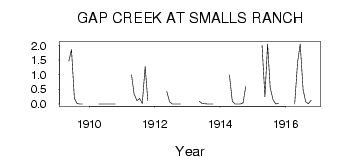
| PointID: | 5234 | Code: | 05HA009 | Latitude (decimal degrees): | 49.79 | Longitude (decimal degrees): | -109.59 | Drainage Area (km2): | 386.00 | Source: | Hydat | Hydrological Zone: | Nelson | Name: | GAP CREEK AT SMALLS RANCH |
|---|
| Download | |
|---|---|
| Site Descriptor Information | Site Time Series Data |
| Link to all available data | |
| ID | Year | Jan | Feb | Mar | Apr | May | Jun | Jul | Aug | Sep | Oct | Nov | Dec |
|---|---|---|---|---|---|---|---|---|---|---|---|---|---|
| 5234 | 1909 | 1.47 | 1.86 | 0.20 | 0.02 | 0.00 | 1.0e-03 | ||||||
| 5234 | 1910 | 0.00 | 4.0e-03 | 0.00 | 0.00 | 0.00 | 0.00 | 0.00 | |||||
| 5234 | 1911 | 1.00 | 0.34 | 0.12 | 0.19 | 0.02 | 1.28 | 0.12 | |||||
| 5234 | 1912 | 0.43 | 0.08 | 0.00 | 3.0e-03 | 0.00 | 2.0e-03 | ||||||
| 5234 | 1913 | 0.09 | 0.02 | 0.01 | 0.00 | 0.00 | 0.00 | ||||||
| 5234 | 1914 | 1.00 | 0.10 | 1.0e-03 | 0.00 | 0.00 | 0.04 | 0.60 | |||||
| 5234 | 1915 | 2.00 | 0.25 | 2.05 | 0.56 | 0.14 | 2.0e-03 | 0.03 | |||||
| 5234 | 1916 | 0.00 | 1.42 | 2.05 | 0.49 | 0.08 | 0.01 | 0.13 |
 Return to R-Arctic Net Home Page