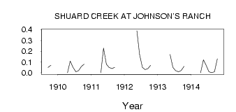
| PointID: | 5230 | Code: | 05HA004 | Latitude (decimal degrees): | 49.83 | Longitude (decimal degrees): | -109.06 | Drainage Area (km2): | 63.50 | Source: | Hydat | Hydrological Zone: | Nelson | Name: | SHUARD CREEK AT JOHNSON'S RANCH |
|---|
| Download | |
|---|---|
| Site Descriptor Information | Site Time Series Data |
| Link to all available data | |
| ID | Year | Jan | Feb | Mar | Apr | May | Jun | Jul | Aug | Sep | Oct | Nov | Dec |
|---|---|---|---|---|---|---|---|---|---|---|---|---|---|
| 5230 | 1909 | 0.05 | 0.07 | ||||||||||
| 5230 | 1910 | 0.00 | 0.11 | 0.05 | 0.01 | 0.02 | 0.06 | 0.08 | |||||
| 5230 | 1911 | 0.00 | 0.23 | 0.08 | 0.05 | 0.04 | 0.05 | ||||||
| 5230 | 1912 | 0.39 | 0.17 | 0.05 | 0.03 | 0.04 | 0.07 | ||||||
| 5230 | 1913 | 0.17 | 0.05 | 0.02 | 0.01 | 0.02 | 0.06 | ||||||
| 5230 | 1914 | 0.00 | 0.12 | 0.07 | 0.01 | 2.0e-03 | 0.01 | 0.13 |
 Return to R-Arctic Net Home Page