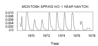
| PointID: | 52 | Code: | 05AB036 | Latitude (decimal degrees): | 50.10 | Longitude (decimal degrees): | -114.03 | Drainage Area (km2): | Source: | Hydat | Hydrological Zone: | Nelson | Name: | MCINTOSH SPRING NO. 1 NEAR NANTON |
|---|
| Download | |
|---|---|
| Site Descriptor Information | Site Time Series Data |
| Link to all available data | |
| ID | Year | Jan | Feb | Mar | Apr | May | Jun | Jul | Aug | Sep | Oct | Nov | Dec |
|---|---|---|---|---|---|---|---|---|---|---|---|---|---|
| 52 | 1968 | 4.0e-03 | 2.0e-03 | 2.0e-03 | 8.0e-03 | 0.00 | 0.00 | ||||||
| 52 | 1969 | 0.00 | 0.00 | 0.00 | 0.00 | 0.01 | 0.01 | 0.01 | 6.0e-03 | 3.0e-03 | 1.0e-03 | 0.00 | 0.00 |
| 52 | 1970 | 0.00 | 0.00 | 0.00 | 0.00 | 3.0e-03 | 6.0e-03 | 5.0e-03 | 2.0e-03 | 1.0e-03 | 1.0e-03 | 0.00 | 0.00 |
| 52 | 1971 | 0.00 | 0.00 | 0.00 | 0.00 | 3.0e-03 | 6.0e-03 | 4.0e-03 | 1.0e-03 | 1.0e-03 | 1.0e-03 | 0.00 | 0.00 |
| 52 | 1972 | 0.00 | 0.00 | 0.00 | 0.00 | 0.01 | 0.01 | 5.0e-03 | 2.0e-03 | 2.0e-03 | 1.0e-03 | 0.00 | 0.00 |
| 52 | 1973 | 0.00 | 0.00 | 0.00 | 0.00 | 0.01 | 0.01 | 5.0e-03 | 2.0e-03 | 1.0e-03 | 1.0e-03 | 0.00 | 0.00 |
| 52 | 1974 | 0.00 | 0.00 | 0.00 | 0.00 | 0.01 | 0.01 | 5.0e-03 | 2.0e-03 | 1.0e-03 | 1.0e-03 | 0.00 | 0.00 |
| 52 | 1975 | 0.00 | 0.00 | 0.00 | 0.00 | 9.0e-03 | 0.01 | 9.0e-03 | 3.0e-03 | 1.0e-03 | 0.00 | 0.00 | 0.00 |
| 52 | 1976 | 0.00 | 0.00 | 0.00 | 5.0e-03 | 3.0e-03 | 5.0e-03 | 5.0e-03 | 2.0e-03 | 0.00 | 0.00 | ||
| 52 | 1977 | 0.00 | 0.00 | 0.00 | 0.00 | 1.0e-03 | 1.0e-03 | 1.0e-03 | 1.0e-03 | 1.0e-03 | 0.00 |
 Return to R-Arctic Net Home Page