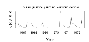
| PointID: | 5173 | Code: | 03KE001 | Latitude (decimal degrees): | 58.02 | Longitude (decimal degrees): | -68.48 | Drainage Area (km2): | 736.00 | Source: | Hydat | Hydrological Zone: | South and East Hudson Bay | Name: | HIGHFALL (RUISSEAU) PRES DE LA RIVIERE KOKSOAK |
|---|
| Download | |
|---|---|
| Site Descriptor Information | Site Time Series Data |
| Link to all available data | |
| ID | Year | Jan | Feb | Mar | Apr | May | Jun | Jul | Aug | Sep | Oct | Nov | Dec |
|---|---|---|---|---|---|---|---|---|---|---|---|---|---|
| 5173 | 1966 | 20.80 | 9.40 | 4.39 | 10.70 | 4.00 | 1.00 | ||||||
| 5173 | 1967 | 0.00 | 0.00 | 0.00 | 0.00 | 23.90 | 22.80 | 20.00 | 8.00 | 2.00 | |||
| 5173 | 1968 | 1.00 | 1.00 | 0.00 | 0.00 | 11.20 | 23.80 | 9.00 | 1.00 | ||||
| 5173 | 1969 | 1.00 | 1.00 | 1.00 | 0.00 | 15.40 | |||||||
| 5173 | 1970 | 1.13 | 83.00 | 7.77 | 8.67 | 3.00 | 1.00 | ||||||
| 5173 | 1971 | 1.00 | 0.00 | 0.00 | 0.00 | 13.90 | 59.60 | 16.70 | 20.60 | 17.40 | 16.50 | 9.00 | 3.00 |
| 5173 | 1972 | 1.00 | 1.00 | 0.00 | 0.00 | 1.33 | 52.10 |
 Return to R-Arctic Net Home Page