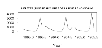
| PointID: | 5171 | Code: | 03KC002 | Latitude (decimal degrees): | 57.68 | Longitude (decimal degrees): | -69.59 | Drainage Area (km2): | 42700.00 | Source: | Hydat | Hydrological Zone: | South and East Hudson Bay | Name: | MELEZES (RIVIERE AUX) PRES DE LA RIVIERE KOKSOAK-2 |
|---|
| Download | |
|---|---|
| Site Descriptor Information | Site Time Series Data |
| Link to all available data | |
| ID | Year | Jan | Feb | Mar | Apr | May | Jun | Jul | Aug | Sep | Oct | Nov | Dec |
|---|---|---|---|---|---|---|---|---|---|---|---|---|---|
| 5171 | 1962 | 526.00 | 573.00 | 320.00 | 214.00 | ||||||||
| 5171 | 1963 | 128.00 | 67.00 | 38.00 | 54.00 | 762.00 | 3180.00 | 969.00 | 1010.00 | 1170.00 | 623.00 | 521.00 | 207.00 |
| 5171 | 1964 | 80.00 | 43.00 | 31.00 | 38.00 | 864.00 | 3340.00 | 614.00 | 396.00 | 987.00 | 1030.00 | 407.00 | 222.00 |
| 5171 | 1965 | 117.00 | 68.00 | 43.00 | 33.00 | 585.00 | 4170.00 | 768.00 |
| Other Close Sites | ||||||
|---|---|---|---|---|---|---|
| PointID | Latitude | Longitude | Drainage Area | Source | Name | |
| 5172 | 57.67 | -69.61 | 42700.00 | Hydat | MELEZES (RIVIERE AUX) PRES DE LA RIVIERE KOKSOAK | |
 Return to R-Arctic Net Home Page