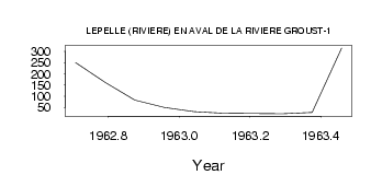
| PointID: | 5166 | Code: | 03HB005 | Latitude (decimal degrees): | 60.19 | Longitude (decimal degrees): | -72.67 | Drainage Area (km2): | 10200.00 | Source: | Hydat | Hydrological Zone: | South and East Hudson Bay | Name: | LEPELLE (RIVIERE) EN AVAL DE LA RIVIERE GROUST-1 |
|---|
| Download | |
|---|---|
| Site Descriptor Information | Site Time Series Data |
| Link to all available data | |
| ID | Year | Jan | Feb | Mar | Apr | May | Jun | Jul | Aug | Sep | Oct | Nov | Dec |
|---|---|---|---|---|---|---|---|---|---|---|---|---|---|
| 5166 | 1962 | 250.00 | 161.00 | 82.00 | 50.00 | ||||||||
| 5166 | 1963 | 31.00 | 24.00 | 22.00 | 21.00 | 27.10 | 315.00 |
| Other Close Sites | ||||||
|---|---|---|---|---|---|---|
| PointID | Latitude | Longitude | Drainage Area | Source | Name | |
| 5165 | 60.19 | -72.66 | 10200.00 | Hydat | LEPELLE (RIVIERE) EN AVAL DE LA RIVIERE GROUST-2 | |
 Return to R-Arctic Net Home Page