| PointID: | 5158 | Code: | 03GD001 | Latitude (decimal degrees): | 59.87 | Longitude (decimal degrees): | -76.59 | Drainage Area (km2): | 13300.00 | Source: | Hydat | Hydrological Zone: | South and East Hudson Bay | Name: | DECOUMTE (RIVIERE) EN AMONT DU LAC DE POVUNGNITUK |
|---|
| Download | |
|---|---|
| Site Descriptor Information | Site Time Series Data |
| Link to all available data | |
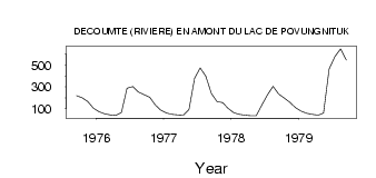
| ID | Year | Jan | Feb | Mar | Apr | May | Jun | Jul | Aug | Sep | Oct | Nov | Dec |
|---|---|---|---|---|---|---|---|---|---|---|---|---|---|
| 5158 | 1975 | 220.00 | 201.00 | 165.00 | 106.00 | ||||||||
| 5158 | 1976 | 73.00 | 55.00 | 45.00 | 39.00 | 66.80 | 288.00 | 302.00 | 254.00 | 230.00 | 204.00 | 135.00 | 88.00 |
| 5158 | 1977 | 62.00 | 50.00 | 45.00 | 42.00 | 92.10 | 377.00 | 472.00 | 398.00 | 240.00 | 166.00 | 156.00 | 103.00 |
| 5158 | 1978 | 63.00 | 48.00 | 41.00 | 38.00 | 36.20 | 135.00 | 227.00 | 304.00 | 234.00 | 197.00 | 158.00 | 110.00 |
| 5158 | 1979 | 79.00 | 60.00 | 49.00 | 42.00 | 60.20 | 464.00 | 577.00 | 647.00 | 546.00 |
 Return to R-Arctic Net Home Page