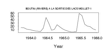
| PointID: | 5153 | Code: | 03FC006 | Latitude (decimal degrees): | 55.57 | Longitude (decimal degrees): | -74.52 | Drainage Area (km2): | 10400.00 | Source: | Hydat | Hydrological Zone: | South and East Hudson Bay | Name: | BOUTIN (RIVIERE) A LA SORTIE DES LACS MOLLET-1 |
|---|
| Download | |
|---|---|
| Site Descriptor Information | Site Time Series Data |
| Link to all available data | |
| ID | Year | Jan | Feb | Mar | Apr | May | Jun | Jul | Aug | Sep | Oct | Nov | Dec |
|---|---|---|---|---|---|---|---|---|---|---|---|---|---|
| 5153 | 1963 | 16.20 | 15.20 | 11.00 | 10.00 | ||||||||
| 5153 | 1964 | 8.00 | 6.00 | 5.00 | 4.00 | 14.20 | 46.50 | 29.10 | 8.09 | 10.50 | 24.60 | 18.00 | 12.00 |
| 5153 | 1965 | 8.00 | 5.00 | 3.00 | 3.00 | 3.86 | 58.70 | 52.30 | 25.90 | 20.50 | 18.60 | 12.00 | 9.00 |
| Other Close Sites | ||||||
|---|---|---|---|---|---|---|
| PointID | Latitude | Longitude | Drainage Area | Source | Name | |
| 5151 | 55.73 | -74.69 | 11700.00 | Hydat | BALEINE (PETITE RIVIERE DE LA) | |
| 5154 | 55.57 | -74.52 | 10400.00 | Hydat | BOUTIN (RIVIERE) A LA SORTIE DES LAC MOLLET-2 | |
| 5155 | 55.68 | -74.33 | 10400.00 | Hydat | BALEINE (PETITE RIVIERE DE LA) EN AMONT DU CHENAL ANCEL | |
 Return to R-Arctic Net Home Page