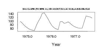
| PointID: | 5148 | Code: | 03FB004 | Latitude (decimal degrees): | 56.18 | Longitude (decimal degrees): | -75.54 | Drainage Area (km2): | 4560.00 | Source: | Hydat | Hydrological Zone: | South and East Hudson Bay | Name: | EAU CLAIRE (RIVIERE A L) EN AMONT DU LAC GUILLAUME-DELISLE |
|---|
| Download | |
|---|---|
| Site Descriptor Information | Site Time Series Data |
| Link to all available data | |
| ID | Year | Jan | Feb | Mar | Apr | May | Jun | Jul | Aug | Sep | Oct | Nov | Dec |
|---|---|---|---|---|---|---|---|---|---|---|---|---|---|
| 5148 | 1974 | 98.50 | 88.50 | 76.00 | 67.00 | ||||||||
| 5148 | 1975 | 59.00 | 54.00 | 50.00 | 48.00 | 75.10 | 97.70 | 117.00 | 143.00 | 145.00 | 128.00 | 110.00 | 89.00 |
| 5148 | 1976 | 73.00 | 63.00 | 57.00 | 54.00 | 97.30 | 98.10 | 87.50 | 90.40 | 96.10 | 87.50 | 78.00 | 71.00 |
| 5148 | 1977 | 66.00 | 62.00 | 61.00 | 61.00 | 94.70 | 128.00 | 125.00 | 123.00 | 117.00 |
 Return to R-Arctic Net Home Page